Unique use cases need unique data sets. Push boundaries and break the status quo with EarthCache-X.
Get fast access to the world’s largest supply of industry-leading remote sensing data
Use new sensor types and diverse formats in customizable, bespoke data sets
Build more robust solutions and get deeper insights with exclusive data providers available through SkyWatch
Task a satellite or order custom data
Optical
Synthetic Aperture Radar (SAR)
Elevation and Stereo
Aerial
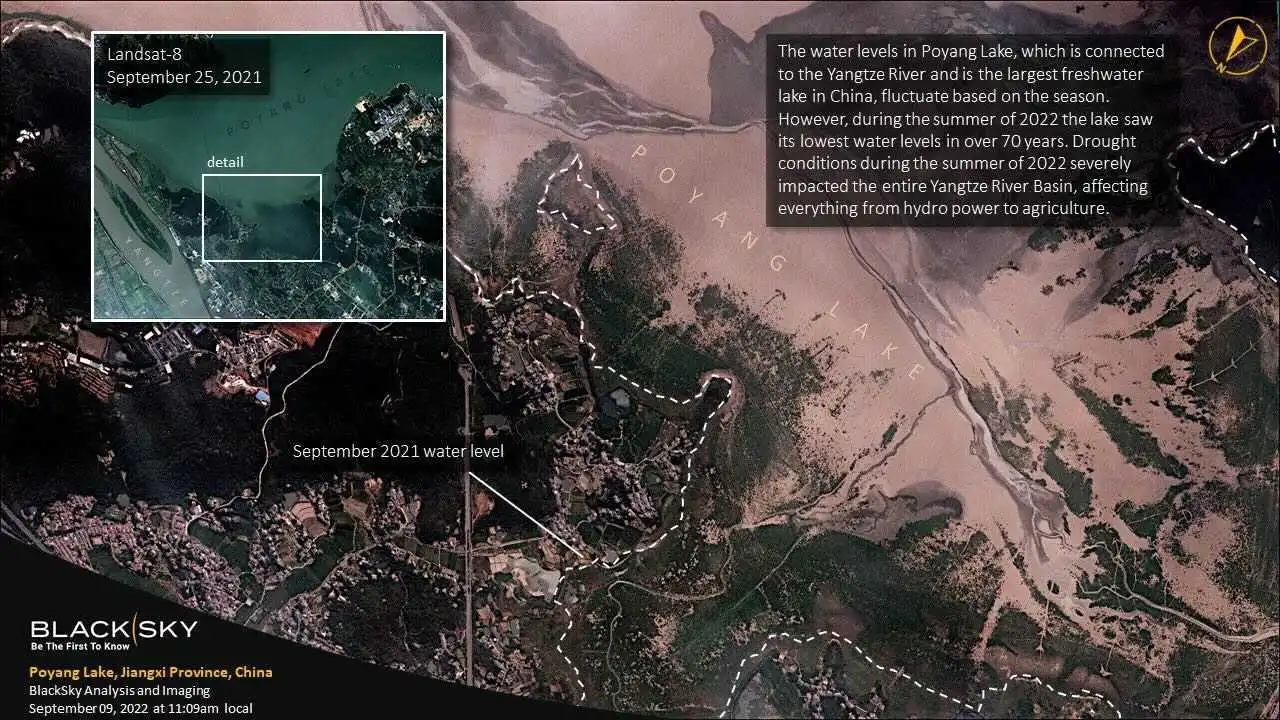
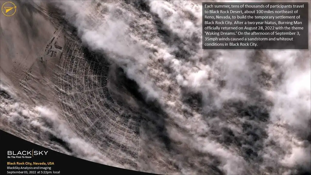
BlackSky
Provides the most timely high-resolution imagery for mid-latitudes.
BlackSky provides reliable on-demand, high-frequency imagery of the most critical and strategic locations, economic assets, and events in the world. Their Global constellation offers multiple collections per day at high resolution, making it an ideal solution for global monitoring in time-sensitive situations.
Common Applications:
Risk Mitigation
Asset Monitoring
Standard Global Series eNIIRS 4.0
Archive
Tasking
Resolution
0.8-1.1 m
Resolution
0.8-1.1 m
Revisit Rate
Intra-daily (~7x)
Revisit Rate
Intra-daily (~7x)
Bands
4 (PAN + RGB)
Bands
4 (PAN + RGB)
Minimum AOI
21-25 km2 at nadir
Minimum AOI
21-25 km2 at nadir
Standard Global Series eNIIRS 3.5
Archive
Tasking
Resolution
1.1-1.5 m
Resolution
1.1-1.5 m
Revisit Rate
Intra-daily (~9x)
Revisit Rate
Intra-daily (~9x)
Bands
4 (PAN + RGB)
Bands
4 (PAN + RGB)
Minimum AOI
24-36 km2 at nadir
Minimum AOI
24-36 km2 at nadir
Area Coverage Global Series eNIIRS 4.0
Archive
Tasking
Resolution
0.8-1.1 m
Resolution
0.8-1.1 m
Revisit Rate
Intra-daily (~7x)
Revisit Rate
Intra-daily (~7x)
Bands
4 (PAN + RGB)
Bands
4 (PAN + RGB)
Minimum AOI
35-50 km2 at nadir
Minimum AOI
24-36 km2 at nadir
Area Coverage Global Series eNIIRS 3.5
Archive
Tasking
Resolution
1.1-1.5 m
Resolution
1.1-1.5 m
Revisit Rate
Intra-daily (~9x)
Revisit Rate
Intra-daily (~9x)
Bands
4 (PAN + RGB)
Bands
4 (PAN + RGB)
Minimum AOI
35-50 km2 at nadir
Minimum AOI
24-36 km2 at nadir
Satellogic
Provides high-resolution images up to 4 times per day.
Satellogic is a vertically integrated EO satellite and data company, offering a 22-satellite constellation with significant archive and 4x daily global revisits at an affordable price point.
Common Applications:
Site Assessment
Site Characterization
NewSat Multispectral-L1
Archive
Tasking
Resolution
0.99 m
Resolution
0.99 m
Revisit Rate
Intra-daily (~4x)
Revisit Rate
Intra-daily (~4x)
Bands
4 (NIR + RGB)
Bands
4 (NIR + RGB)
Minimum AOI
50 km2 5 km width
Minimum AOI
50 km2 5 km width
NewSat Multispectral-Super Resolution
Archive
Tasking
Resolution
0.7 m
Resolution
0.99 m
Revisit Rate
Available upon request
Revisit Rate
Available upon request
Bands
4 (NIR + RGB)
Bands
4 (NIR + RGB)
Minimum AOI
100 km2 5 km width
Minimum AOI
100 km2 5 km width
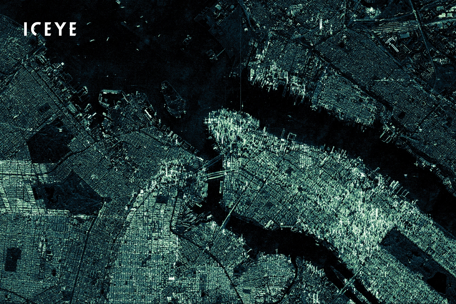
ICEYE
Provides coherent and extremely high-precision SAR for daily change detection.
Possessing the world’s largest SAR satellite constellation, ICEYE's high revisit and daily coherent change detection capabilities enable users to gain robust and comprehensive situational awareness.
Common Applications:
Asset Monitoring
Risk Mitigation
Spotlight Extended Area
Archive
Resolution
1 m
Revisit Rate
Intra-daily (~3x near equator, ~20x near poles)
Bands
1 (X-band)
Polarization
VV
Swath
15 km x 15 km
Spotlight
Archive
Resolution
1 m
Revisit Rate
Intra-daily (~3x near equator, ~20x near poles)
Bands
1 (X-band)
Polarization
VV
Swath
5 km x 5 km
Stripmap
Archive
Resolution
3 m
Revisit Rate
Intra-daily (~3x near equator, ~20x near poles)
Bands
1 (X-band)
Polarization
VV
Swath
50 km x 30 km
Scan
Archive
Resolution
15 m
Revisit Rate
Dependent upon requirements
Bands
1 (X-band)
Polarization
VV
Swath
100 km x 100 km
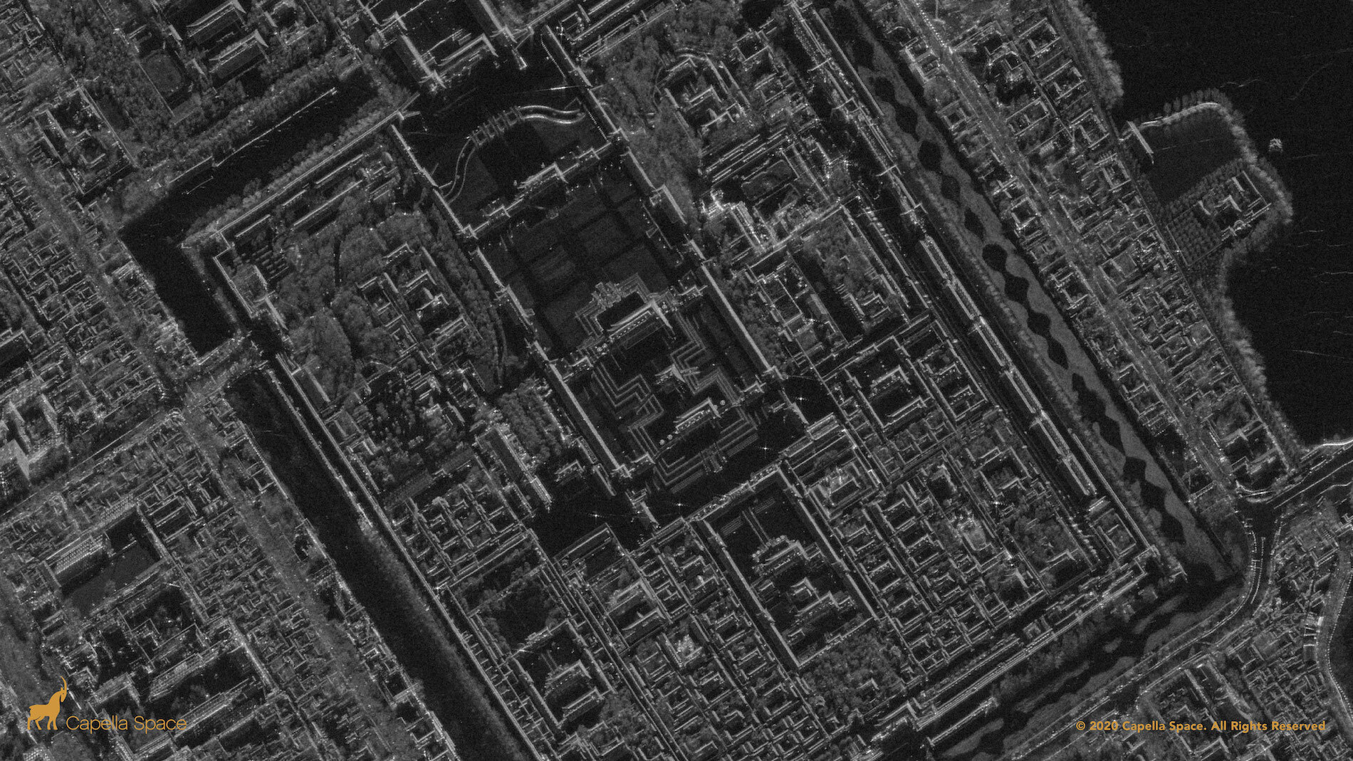
Capella Space
Provides an extensive constellation of very high resolution SAR, offering rapid revisit (5 hour average)
Capella Space has the most responsive and agile SAR imaging services in the industry on the leading edge of rapid data acquisition for emergencies or tip and cue.
Common Applications:
Asset Monitoring
Risk Mitigation
Spot-Spotlight
Archive
Tasking
Resolution
0.5 m
Resolution
0.5 m
Revisit Rate
Intra-daily (~5x)
Revisit Rate
Intra-daily (~5x)
Bands
1 (X-band)
Bands
1 (X-band)
Polarization
HH
Polarization
-
Swath
5 km x 5 km
Swath
5 km x 5 km
Site-Sliding Spot
Archive
Tasking
Resolution
1 m
Resolution
1 m
Revisit Rate
Intra-daily (~5x)
Revisit Rate
Intra-daily (~5x)
Bands
1 (X-band)
Bands
1 (X-band)
Polarization
HH
Polarization
-
Swath
5 km x 10 km
Swath
5 km x 10 km
Strip-Stripmap
Archive
Tasking
Resolution
1.2 m
Resolution
1.2 m
Revisit Rate
Intra-daily (~5x)
Revisit Rate
Intra-daily (~5x)
Bands
1 (X-band)
Bands
1 (X-band)
Polarization
HH
Polarization
-
Swath
5 km x 20 km
Swath
5 km x 20 km
Airbus
Owner of the largest commercial constellation of optical and radar EO satellites on the market.
Airbus SAR products deliver flexible high-resolution or wide area coverage SAR data offering reliability, high revisit, and weather-independent data capture.
Common Applications:
Asset Monitoring
Risk Mitigation
Urban Planning/Mapping
TerraSAR-X, Staring Spotlight
Archive
Tasking
Azimuth Resolution
0.25 m
Azimuth Resolution
0.25 m
Revisit Rate
Daily
Revisit Rate
Daily
Bands
1 (X-band)
Bands
1 (X-band)
Polarization
Single (HH or VV)
Polarization
Single (HH or VV)
Minimum AOI
14.8 km2
Minimum AOI
14.8 km2
TerraSAR-X, High-Res Spotlight
Archive
Tasking
Resolution
1 m
Resolution
1 m
Revisit Rate
Daily
Revisit Rate
Daily
Bands
1 (X-band)
Bands
1 (X-band)
Polarization
Single (HH or VV) or Dual (HH & VV)
Polarization
Single (HH or VV) or Dual (HH & VV)
Minimum AOI
50 km2
Minimum AOI
50 km2
TerraSAR-X, Spotlight
Archive
Tasking
Azimuth Resolution
2 m
Azimuth Resolution
2 m
Revisit Rate
Daily
Revisit Rate
Daily
Bands
1 (X-band)
Bands
1 (X-band)
Polarization
Single (HH or VV) or Dual (HH & VV)
Polarization
Single (HH or VV) or Dual (HH & VV)
Minimum AOI
100 km2
Minimum AOI
100 km2
TerraSAR-X, Stripmap
Archive
Tasking
Azimuth Resolution
3 m
Azimuth Resolution
3 m
Revisit Rate
Daily
Revisit Rate
Daily
Bands
1 (X-band)
Bands
1 (X-band)
Polarization
Single (HH or VV) or Dual (HH & VV, HH & HV or VV & VH)
Polarization
Single (HH or VV) or Dual (HH & VV, HH & HV or VV & VH)
Minimum AOI
150 km2
Minimum AOI
150 km2
TerraSAR-X, ScanSAR
Archive
Tasking
Azimuth Resolution
18.5 m
Azimuth Resolution
18.5 m
Revisit Rate
Daily
Revisit Rate
Daily
Bands
1 (X-band)
Bands
1 (X-band)
Polarization
Single (HH or VV)
Polarization
Single (HH or VV)
Minimum AOI
1500 km2
Minimum AOI
1500 km2
TerraSAR-X, Wide ScanSAR
Archive
Tasking
Azimuth Resolution
40 m
Azimuth Resolution
40 m
Revisit Rate
Daily
Revisit Rate
Daily
Bands
1 (X-band)
Bands
1 (X-band)
Polarization
Single (HH, VV, HV or VH)
Polarization
Single (HH, VV, HV or VH)
Minimum AOI
5400 km2
Minimum AOI
5400 km2
BlackSky
Provides the most timely high-resolution imagery for mid-latitudes.
BlackSky's rapidly expanding constellation provide high revisit rate cadence, responsive last-minute tasking and timely collect-to-data-delivery latency timeframes in the mid-latitudes, perfect for on-demand stereo imagery acquisition.
Common Applications:
Site Assessment
Urban Planning/Monitoring
Stereo Global Series
Archive
Tasking
Resolution
0.8-1.5 m
Resolution
0.8-1.5 m
Bands
4 (PAN + RGB)
Bands
4 (PAN + RGB)
Minimum AOI
21-36 km2 at nadir
Minimum AOI
21-36 km2 at nadir
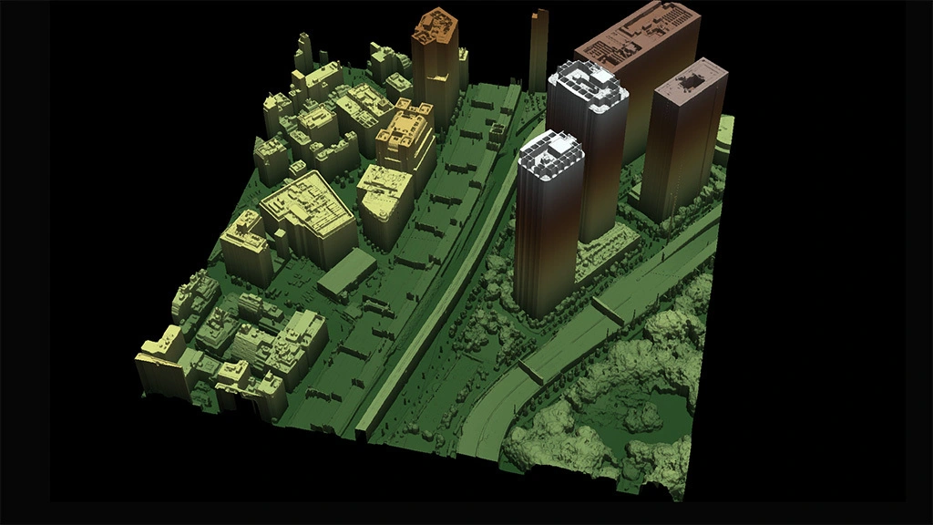
Vexcel Data Program
Leading provider of aerial imagery and DEM provider with resolutions as high as 7.5 cm.
Vexcel runs the world’s largest aerial imagery and geospatial data program, collecting multiple types of aerial content in 25+ countries, with imagery and data that are also optimized for ML/AI capabilities.
Common Applications:
Site Assessments
Urban Planning/Monitoring
DSM
Archive
Resolution
7.5 cm
Bands
1
Coverage
20+ countries (US, CAN, EU, JP, AU/NZ)
DSM
Archive
Resolution
15-20 cm
Bands
1
Coverage
20+ countries (US, CAN, EU, JP, AU/NZ)
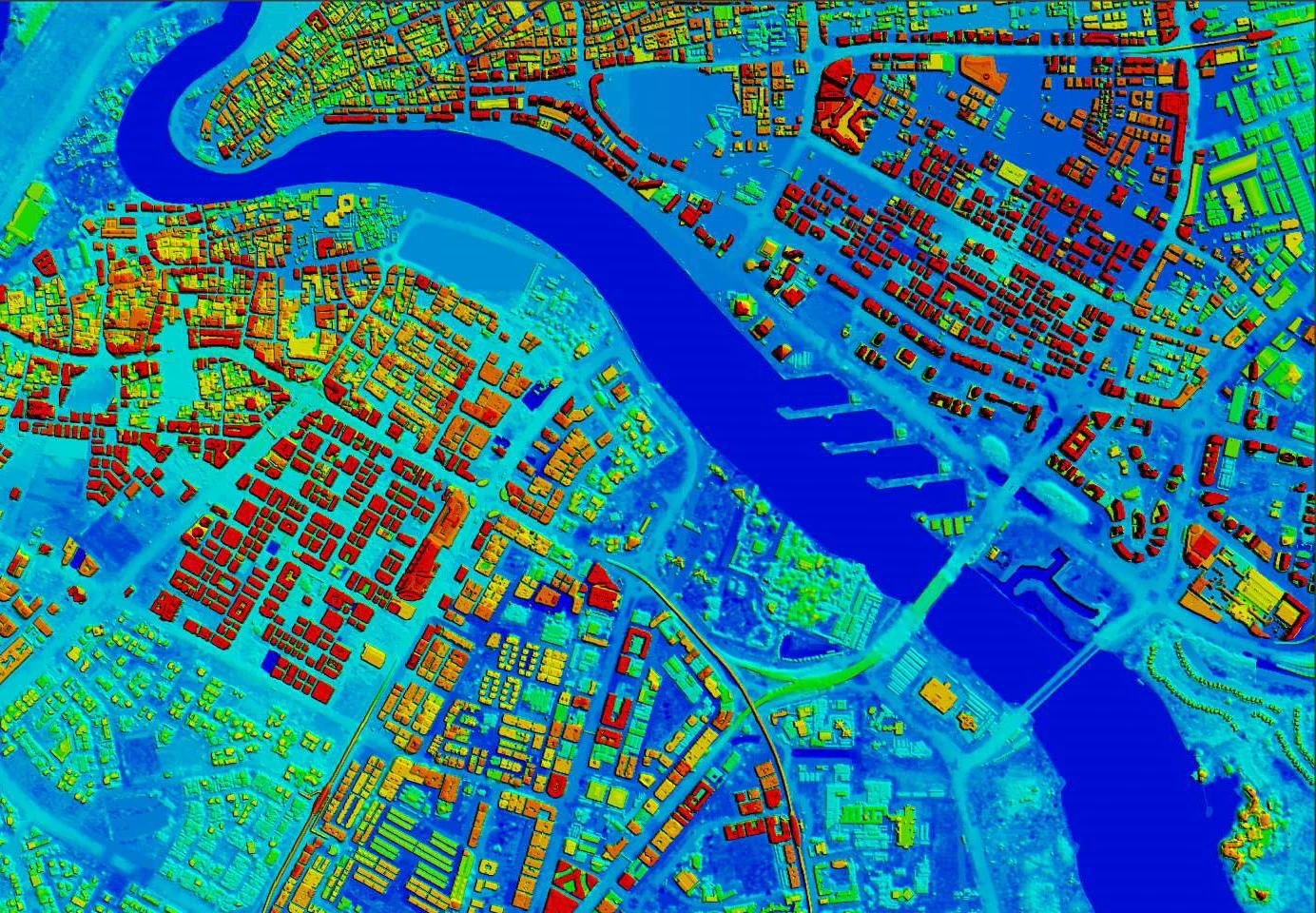
Airbus
Owner of the largest commercial constellation of optical and radar EO satellites on the market.
Leveraging their powerful satellite constellation, Airbus produces Digital Surface Models (DSM) and Digital Terrain Models (DTM) at 1m, 4m, 5m, 12m, and 24m resolutions. In areas without existing stereo imagery, their agile satellite constellation provides the flexibility to collect new imagery for a custom DEM at even higher resolutions such as with the Pléiades Neo constellation, flaunting four identical 30cm resolution satellites with stereo and tri-stereo capacity
Common Applications:
Site Assessments
Urban Planning/Monitoring
OnePlan Pleaides Neo - Stereo/Tri-Stereo
Archive
Tasking
Resolution
0.3 m
Resolution
0.3 m
Bands
4
Bands
4
Minimum AOI
25 km2 area 500 m width
Minimum AOI
25 km2 area 5 km width
Elevation 1
Archive
Resolution
1 m
Bands
1
Minimum AOI
N/A
Elevation 4
Archive
Resolution
4 m
Bands
1
Minimum AOI
N/A
WorldDEM
Archive
Resolution
5 m 12 m 24 m
Bands
1
Minimum AOI
N/A
Planet
With an industry-leading combination of coverage and cadence, Planet delivers EO data at an unprecedented scale.
With their sub-meter high-resolution satellite constellation, Planet's SkySat data enables users to make timely and accurate assessments on a near real-time basis as well as robust planning solutions.
Common Applications:
Site Assessments
Urban Planning/Monitoring
Planet SkySat - Stereo/Tri-Stereo
Archive
Tasking
Resolution
0.5 m
Resolution
0.5 m
Bands
5 (PAN + RGB + NIR)
Bands
5 (PAN + RGB + NIR)
Minimum AOI
25 km2 area
Minimum AOI
25 km2 area
Vexcel Data Program
Leading provider of aerial imagery and DEM provider with resolutions as high as 7.5 cm.
Vexcel runs the world’s largest aerial imagery and geospatial data program, collecting multiple types of aerial content in 25+ countries, with imagery and data that are also optimized for ML/AI capabilities.