Conversations about satellite data are usually geared around a few narrow industries. However, there is much more that can be done with this technology regarding healthcare. For instance, earth-observation imagery can provide insight and information about the wellness of populations on a larger scale. Healthcare entities can benefit from this knowledge and employ proactive strategies to ensure better treatment of people across the globe.
Listed below are five ways satellite data can aid in improving worldwide healthcare.

5. Monitoring Water Levels and Water Evaporation
According to the United Nations, as of 2013, over 2.5 billion people are without access to safe drinking water, a number that is increasingly rising. In the near future, water management will become a major task for humanity. Even nations that currently have this luxury may find it difficult to maintain their access to clean water as populations grow and climate change begins to influence the hydrosphere. Monitoring the levels of rivers and lakes, evaporation rate, ground moisture content and pollutants in the air (i.e. acid rain) is no longer just interesting – it is necessary to safeguard millions of lives. This is where climate satellites will be beneficial; low-cost devices used in orbit to measure Earth’s water cycle that can assist in optimizing worldwide access to safe drinking water.
Link to World Water Day.
4. Identifying Dangerous Mosquito Populations
Mosquitoes have been identified as carriers of several serious illnesses, including malaria, yellow fever, and tuberculosis. Determining their habitats can be done by recognizing plant type, air quality, surface features, and amount of water in an area. Remote sensing experts use multispectral and hyperspectral satellites to assess the locality of mosquito dwellings, identify the type of mosquitoes in the environment, and contemplate if they could cause harm. This information can help healthcare professionals assess treatment necessities and plan a proper response, particularly where there is limited medical assistance or many cases of mosquito-caused diseases.
3. Measuring Air-Borne Particulate Levels
Elon Musk’s pronouncement that filtering particulates from the air can make a significant and measurable difference to health is a powerful reminder of the business community’s commitment to creating a cleaner world. To effectively tackle this challenge, satellite data must be used to identify which parts of the world are seeing problematic increases in airborne particles near the Earth’s surface. Before 2010, it was difficult to generate such data due to satellite limitations, but two scientists in Canada eventually achieved it by combining NASA datasets. Thanks to this breakthrough, it is now possible for medical professionals to gauge the impact of air pollution on population health with greater accuracy and develop targeted solutions accordingly.
2. Projecting the Severity of Seasonal Allergy Symptoms
It’s almost certain that you or someone close to you suffers from seasonal allergies. In the United States, over 40 million adults experience itchy eyes and a runny nose when springtime comes around. This is expected to become worse as CO2 levels continue to rise. Ragweed, ryegrass, and mulberry bushes flourish in carbon dioxide-rich conditions and grow faster than crops like corn, rice, and apple trees. An abundance of pollen increases allergy symptoms, resulting in chest tightness and breathing difficulties for those affected—rather than just taking over-the-counter medication. To prepare for this trend, healthcare professionals can take advantage of satellites such as NASA’s Orbiting Carbon Observatory (OCO-2), which detect areas with higher-than-normal concentrations of CO2. In doing so, doctors and nurses are better equipped to anticipate a rise in patients seeking medical attention due to their allergies.
1. Identifying Large Carbon Emitters
Climate change is a topic of dire concern for the well-being of future generations. While it does not directly impact our body as Particulate Matter does, its indirect effects are damaging. Global warming has been attributed to increased extreme weather events, like hurricanes, severe storms, wildfires and flooding, which lead to displacement and poorer health statistics. Several satellites like NASA’s MOPITT and TES help measure greenhouse gas levels in the troposphere – although they cannot pinpoint specific polluters yet. If international pressure is directed at countries producing high emissions volumes, large-scale carbon regulation can be implemented. This will be key to maintaining the health and happiness of populations which remain safely in their homes.
In the coming years, hundreds more satellites will be launched into orbit to observe our planet. Using these instruments; we can better understand our planet and its effects on the world’s health. Let us take advantage of this advantage to help improve healthcare worldwide.

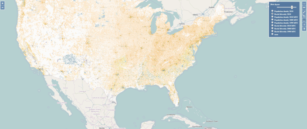
Although the US government collects Census data at the household level, it renders it in aggregated blocks for privacy reasons. End-users without GIS experience may also have difficulty comparing data and finding long-term patterns because the block lines might fluctuate between surveys.
By leveraging LandSat-8 satellite data, land cover information, dasymetric modelling, and a statistical model that allocates people only to populated sites, Professor Stepinski and his team could create an immensely precise map of the United States right down to the street level. This new visualization helps even people who aren’t tech-savvy observe transformations over time –”from year to year and pixel to pixel”– as the grid remains constant. As things stand today, this map displays Census information from 1990, 2000 and 2010; however, Professor Stepinski plans to introduce the 2020 data once it is accessible to the public.
While waiting for the data, professor Stepinski is currently developing a model to predict changes in the diverse landscape in the United States. A functional model on population migration patterns would be an asset for many industries and government functions, ranging from city planning, urban development, disaster prevention, or even retail and commerce looking into new locations to open stores.


