Satellite imagery for media has become a real competitive advantage for newsrooms looking to strengthen their coverage.
Earth observation technology gives journalists a practical way to monitor areas of interest and detect changes in developing stories. Investigative reporters in particular benefit from satellite data, because consistent monitoring is a safe and cost-effective way to follow up on leads, often in places where physical access is denied.
That advantage is increasingly visible in award-winning work. In 2025, newsrooms used satellite imagery to verify and geolocate events on the ground: The Guardian annotated before-and-after Maxar imagery to show what the magnitude 7.7 earthquake damaged in Mandalay and Sagaing, Myanmar, and Reuters paired satellite imagery with documents to map how Iran built a multibillion-dollar oil trade despite sanctions (Global Investigative Journalism Network).
When using satellite data, journalists can choose from several resolution types and data outputs, which makes it possible to monitor a region over long periods on a reasonable budget. The best part is that reporters do not need to be physically present to capture these moments in time.
Satellite imagery is an affordable tool that gives journalists the flexibility and reliability they need for their analysis, whether the goal is to monitor remote areas to protect physical safety or to track a hurricane for frequent updates.
Here are three ways media companies use satellite imagery for media as a competitive advantage.

Visualizing Global Events
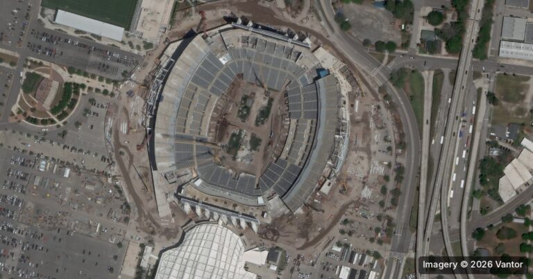
Satellite imagery can capture visuals of natural disasters, political conflicts, and environmental changes. A clear example is BAP Intel, a SkyWatch customer who went from hobbyist to professional analyst by monitoring the Ukrainian border in 2022, capturing imagery to detect movement and document changes over time.
The most common output used to visualize these events is true color, which provides an authentic view of an area of interest and shows what that point looked like at the moment of capture. By incorporating high-resolution satellite imagery into their analysis, news organizations can give viewers a first-hand view of the impact of an event. Comparisons of images captured before and after a global event are especially compelling, and they help verify that journalists are working from a strong, independent source.
Updated Imagery
Staying current on world events is easier with satellite data. Working with an aggregator like SkyWatch, journalists can access historical archives as well as task imagery for a future date. The ability to task an image with a low latency period is an effective way to stay relevant as new developments unfold. How often you monitor an area ultimately depends on budget, but from a capability standpoint, satellites can be tasked daily and, with some providers, multiple times a day. Many media customers find this invaluable for following a fast-moving story.
Data-Driven Reporting
When reporting on complex topics such as climate change, outputs beyond true color can expand a journalist’s analysis. An Enhanced Vegetation Index (EVI) output, for example, reveals vegetation changes that an optical image alone cannot show. This adds a layer of data-driven reporting to journalist narratives, making them more informative and insightful.
The SkyWatch platform also provides API access, making it easy to programmatically collect and analyze data. Analysts and GIS specialists commonly use tools such as ArcGIS Pro by Esri to work with imagery, and SkyWatch BUILD gives developer-minded newsrooms pay-as-you-use access to 400+ data providers through a single API. Teams with geospatial expertise can also bring imagery directly into ArcGIS Pro with SkyWatch MAP, which streamlines analysis inside the GIS tools they already use.
Consistent Monitoring
The ability to detect change and monitor areas of interest remotely becomes possible with satellite data.
Resource Optimization
Using the SkyWatch API, media organizations can efficiently source data for further analysis.
Reliable Sources
Improve the reliability and accuracy of news coverage by ensuring timely captures and accurate attributions.
Why Satellite Imagery for Media Matters
Satellite imagery analysis is an effective and versatile tool for media companies looking to strengthen their news coverage. It offers a cost-effective and secure way to monitor areas of interest, detect changes in developing stories, and visualize global events with accuracy and precision. Used alongside traditional reporting, satellite data helps journalists establish timelines, verify claims, and document patterns when physical access is impossible.
The ability to access updated imagery and apply data-driven reporting tools broadens a journalist’s analysis, surfacing patterns and trends that might otherwise go unnoticed. That makes reports more informative and insightful, and it gives newsrooms a competitive edge in a crowded media landscape.
Ready to add satellite imagery to your reporting? Start discovering and purchasing imagery with SkyWatch EXPLORE, or talk to our team about a monitoring program built for your newsroom.