
Oil and gas satellite monitoring keeps operations running effectively and safely. It supports safety, compliance, and performance, and it remains one of the most reliable ways to prevent environmental damage and protect workers and nearby communities.
Satellite imagery has changed how companies watch their sites. Teams can now review assets daily or weekly, keep records current, and detect environmental changes as they happen. That shift matters more than ever: the fossil fuel sector accounts for nearly one-third of human-caused methane emissions, and there are now more than 25 satellites in orbit capable of detecting methane, which gives operators far more visibility into their own footprint (IEA Global Methane Tracker 2025; EESI).
This guide covers the six areas where oil and gas companies should focus their satellite monitoring, plus the benefits each one delivers.
Six Critical Areas for Oil and Gas Satellite Monitoring
Oil and gas companies should focus their monitoring on six areas:
- Asset monitoring and management
- Environmental impact assessment
- Emergency response and crisis management
- Security and surveillance
- Compliance and regulatory reporting
- Remote and inaccessible areas
1. Asset Monitoring and Management
Pipeline Monitoring
Pipelines move oil and gas safely, which matters for both the economy and the environment. Leaks or ruptures can cause spills or explosions, so catching problems early is critical.
Satellite imagery helps companies do this. By reviewing the full length of a pipeline on a regular basis, teams can spot signs of corrosion, encroachment, or ground movement quickly. They can then schedule maintenance before a small problem becomes a leak, reducing risk and limiting environmental harm.
Facility Monitoring
Satellite imagery is also valuable for monitoring production facilities and storage tanks. High- and very-high-resolution images reveal small structural changes, equipment problems, and potential hazards, so companies can act early to reduce risk and keep operations safe.
Companies can also track vegetation around facilities and critical infrastructure, catching encroachment before plants grow too close and cause operational or safety problems.
Key benefits
- Enhanced safety — early detection protects workers and nearby communities.
- Cost and time savings — proactive, data-driven maintenance reduces the need for frequent manual inspections.
- Optimized resource allocation — teams target repairs and maintenance where they are needed most.
2. Environmental Impact Assessment
Vegetation Monitoring
Tracking the health and growth of nearby vegetation is a key part of assessing environmental impact. With satellite imagery and remote sensing, companies can monitor changes in vegetation and flag stressors or abnormalities.
Data outputs such as NDVI, MSAVI2, EVI, and NDWI2 reveal specific changes in plants, soil, and water. Spotting these changes early helps companies prevent environmental damage, stay compliant with regulations, and operate more responsibly.
Land Use Changes
Monitoring how land use changes over time supports responsible resource management. Satellite imagery shows how operations affect the local ecosystem and highlights areas that need attention. This information improves compliance reporting and supports better decisions about sustainable resource use.
Key benefits
- Informed decision-making — satellite data guides strategic land management.
- Sustainable land management — ongoing monitoring supports sustainable practices and protects natural resources.
- Opportunity identification — early detection highlights areas worth preserving or conserving.
3. Emergency Response and Crisis Management
Disaster Monitoring
When a disaster strikes, satellites capture imagery of the affected area. This data helps teams plan their emergency response, keep personnel safe, and limit damage to infrastructure.
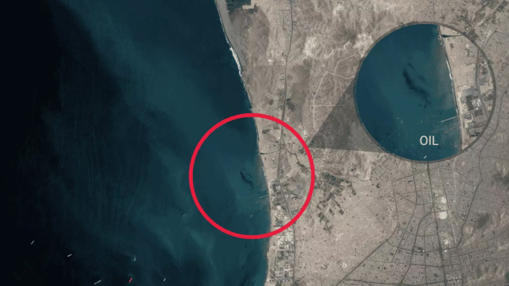
Spill Detection
A fast, effective response limits the damage from an oil spill. Satellites help companies detect spills early and pinpoint the exact areas that need attention, so response teams can deploy containment measures quickly.
Companies can also compare the land before and after a spill. This shows what changed and helps teams plan remediation and cleanup. Oil spills are dangerous for both the environment and cleanup crews, so satellite data is a valuable tool for reducing direct contact with the site.
Key benefits
- Rapid assessment — before-and-after imagery speeds up disaster impact assessment.
- Resource optimization — accurate data guides where to send emergency resources.
- Community support — detailed records support insurance claims and help affected communities.
4. Security and Surveillance
Monitoring Illegal Activity
Oil and gas sites are vulnerable to theft and unauthorized access. Satellite imagery strengthens security with regular monitoring, so companies can identify and respond to illegal activity quickly, protecting their assets and operations.
Site Security
For sites in remote or difficult terrain, satellite imagery helps monitor facilities, infrastructure, and perimeters. It gives companies a complete view of the operational area, making it easier to detect and deter security threats.
5. Compliance and Regulatory Reporting
Reporting and Documentation
Compliance matters in the oil and gas sector, and scrutiny is increasing. Recent satellite assessments found that methane emissions from oil and gas basins worldwide far exceed what is reported in official inventories, putting more pressure on operators to measure and document their own impact accurately (Inside Climate News). Satellite data provides reliable, detailed records of operations and their environmental impact. Because this information is accurate and up to date, it helps companies meet regulatory requirements while improving transparency and accountability.
6. Remote and Inaccessible Areas
Inaccessible Terrain
Some oil and gas facilities sit in remote or challenging terrain, which makes on-site monitoring difficult. Satellite imagery solves this by providing a bird’s-eye view of these areas. It lowers the operational cost of physical inspections and reduces the risks to personnel working in tough environments.
Conclusion
Oil and gas satellite monitoring has reshaped how the industry manages its sites, from proactive asset management to environmental impact assessment and crisis response. It lets site managers track asset condition, watch for environmental changes, and respond quickly to emergencies, while reducing the need for slow and expensive site visits.
By combining satellite imagery with other monitoring and inspection methods, oil and gas companies get a complete picture of their sites and infrastructure. The result is greater efficiency, improved safety, and reduced environmental impact.
Teams that need to source imagery on demand can start with SkyWatch EXPLORE to discover and purchase satellite imagery, while enterprise programs can scale procurement and data management through SkyWatch HUB. To build satellite monitoring directly into your own workflows and applications, SkyWatch BUILD provides API access to 400+ data providers.
Ready to put oil and gas satellite monitoring to work? Talk to our team to scope the right solution for your sites.


