Regulatory compliance is rarely the most glamorous part of business operations, but for industries like mining, energy, and construction, it is arguably the most critical. One missed report or unnoticed environmental violation can lead to hefty fines, project shutdowns, or reputational damage.
Traditionally, monitoring compliance meant sending teams into the field, which is expensive, time-consuming, and often dangerous work. But the landscape is shifting. Today, we are seeing a surge in enterprises leveraging high-resolution satellite imagery to monitor their assets remotely, effectively, and frequently. By integrating geospatial data into compliance workflows, organizations can spot issues before they become violations, ensuring operations run smoothly and safely.
In this post, we’ll explore how satellite imagery transforms compliance monitoring, specific use cases across industries, and why this technology is becoming a standard for operational excellence.
The Challenge of Modern Compliance
For site managers and safety officers in sectors like Oil & Gas or Utilities, the scope of responsibility is massive. You might be managing hundreds of miles of pipelines, remote mining sites, or complex urban infrastructure projects.
Regulatory bodies are becoming stricter, demanding more frequent reporting and higher standards for environmental protection and safety. The old methods of annual audits or sporadic site visits just don’t cut it anymore. You need eyes on the ground, or eyes in the sky, 24/7.
Manual inspections have significant limitations:
- Safety Risks: sending personnel to remote or hazardous locations increases the risk of injury.
- High Costs: Field teams require travel, equipment, and significant man-hours.
- Data Gaps: Infrequent visits mean you only get a snapshot in time, potentially missing violations that occur between inspections.
Satellite imagery bridges these gaps, offering a reliable, consistent, and safe way to monitor vast areas.
Key Use Cases: Monitoring from Above
Satellite technology isn’t just about taking pretty pictures of the Earth; it’s about extracting actionable data. Here is how enterprises are using this data to stay compliant.
1. Environmental Monitoring and Deforestation Tracking
Strict environmental regulations often bind mining and energy projects. Companies must ensure their operations do not encroach on protected lands or exceed approved deforestation limits.
With high-frequency satellite imagery, environmental officers can track vegetation changes over time. Automated change detection algorithms can flag if clearing has gone beyond the permitted zone. This allows managers to intervene immediately, correcting the issue before a regulatory audit uncovers a violation.
2. Emissions and Pollution Control
Newer satellite constellations are equipped with sensors capable of detecting methane leaks and other emissions. For the Oil & Gas industry, this is a game-changer. Instead of relying solely on ground sensors, which may not cover every inch of a pipeline, satellite data can provide a broad overview of emission concentrations.
Identifying a leak early not only prevents environmental damage but also ensures compliance with increasingly rigorous emission standards. It demonstrates a proactive approach to safety and stewardship, which is invaluable for stakeholder relations.
3. Land Use and Zoning Verification
For State & Local Governments and AEC (Architecture, Engineering, and Construction) firms, ensuring that land use matches zoning laws is a constant battle. Unauthorized construction or land misuse can create legal headaches and safety hazards.
Satellite imagery provides an undisputed record of land use. Urban planners can compare current imagery against zoning maps to identify discrepancies. This allows for quicker enforcement actions and ensures that development projects align with city planning regulations.
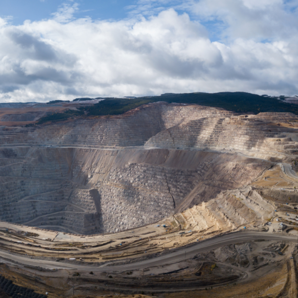
4. Tailings Dam Stability
In the mining sector, the stability of tailings dams is a critical safety and compliance issue. Failure can result in catastrophic environmental damage and loss of life. Interferometric Synthetic Aperture Radar (InSAR) is a specific type of satellite technology that can detect millimeter-level ground deformation.
By monitoring these structures from space, safety officers can detect subtle shifts in the ground that might indicate instability. This early warning system allows for preventative maintenance, ensuring compliance with safety regulations and protecting workers and the environment.
The Strategic Advantages of Satellite Data
Why should an enterprise invest in satellite imagery for compliance? The benefits go beyond just “following the rules.”
Real-Time and Historical Insight
One of the biggest advantages is the ability to access near real-time data. You don’t have to wait weeks for a field report. Furthermore, historical archives allow you to look back in time. If a regulator questions when a specific activity started, you can pull imagery from that exact timeframe to prove your compliance.
Cost-Effectiveness at Scale
While there is an upfront cost to accessing high-quality imagery, it pales in comparison to the operational costs of frequent physical inspections. For utilities monitoring vegetation along thousands of miles of transmission lines, satellite imagery offers a far more economical solution than deploying helicopter patrols or ground crews for every mile.
Global Reach and Accessibility
Many energy and mining operations are located in remote, hard-to-access regions. Satellite imagery provides consistent monitoring capabilities regardless of location. Whether your asset is in the middle of a desert or deep in the jungle, you have the same level of visibility as you would for a site in the city suburbs.
Future-Proofing Your Compliance Strategy
The capabilities of satellite technology are advancing rapidly. We are moving toward a future where “revisiting” a site via satellite happens daily or even hourly.
Advancements in AI and machine learning are also making it easier to interpret this data. You won’t need to be a geospatial expert to spot a compliance issue; intelligent dashboards will automatically alert safety officers to anomalies, such as a vehicle in a restricted zone or unexpected vegetation growth near power lines.
For enterprises looking to maintain a competitive edge, integrating satellite imagery into compliance workflows is a logical step. It transforms compliance from a reactive burden into a proactive strategy.
Actionable Next Steps
If you are ready to enhance your compliance strategy with satellite imagery, consider these steps:
- Audit Your Current Risks: Identify which areas of your operation pose the highest compliance risks (e.g., remote pipelines, tailing dams, construction boundaries).
- Define Your Data Needs: Determine if you need optical imagery (visual) or radar data (InSAR for ground movement), and how frequently you need updates.
- Explore Integration: Look for platforms that integrate satellite data directly into your existing GIS or asset management workflows to ensure seamless adoption by your team.
By embracing these tools today, you ensure your enterprise is ready for the regulations of tomorrow. Get started with satellite imagery now.