Aerial Imagery is Now Available in Content Store for ArcGIS
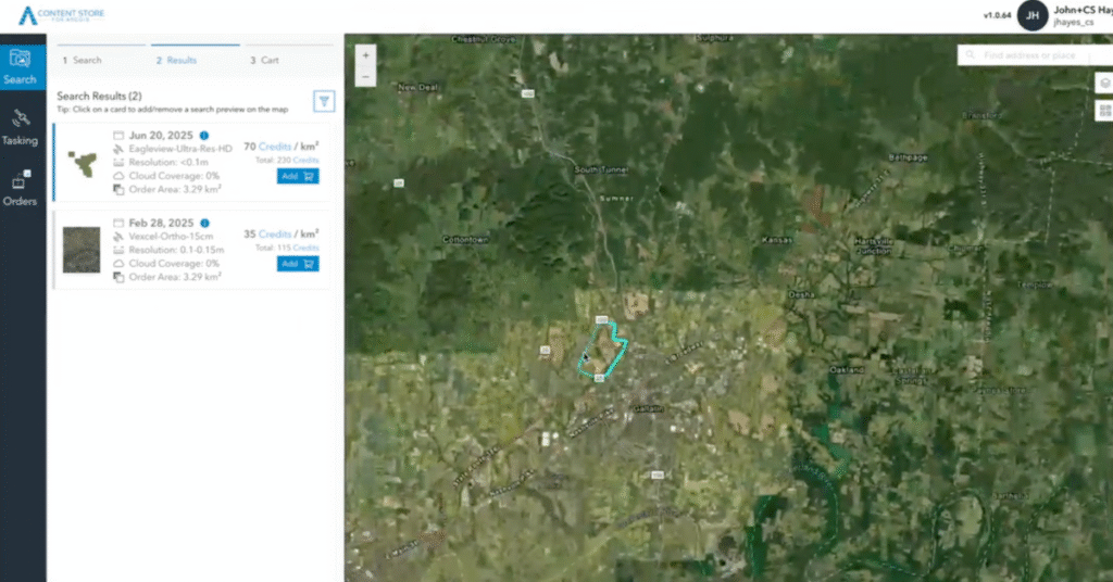
At SkyWatch, we’re on a mission to make Earth observation data more accessible, discoverable, and useful than ever before. That’s why we’re excited to announce that high-resolution aerial imagery from leading providers is now available directly through SkyWatch’s Content Store for Esri ArcGIS. Content Store makes it easy for ArcGIS users to browse, preview, and […]
A New Perspective: Aerial Imagery Now Available on SkyWatch

At SkyWatch, we’re always working to make the world’s geospatial data more accessible, discoverable, and usable. Today, we’re excited to announce a major step forward: high-resolution aerial imagery is now available on the SkyWatch platform. Through our recently announced collaboration with Eagleview, you can now access premium aerial imagery alongside satellite data. With this new […]
Announcing SAR Tasking Availability on SkyWatch HUB and EXPLORE

We’re thrilled to announce that synthetic aperture radar (SAR) tasking capabilities have been added to SkyWatch HUB, and both archive and tasking options are now available in SkyWatch EXPLORE. This significant expansion of our platform capabilities empowers users with new tools to access synthetic aperture radar (SAR) data, providing enhanced flexibility and precision for geospatial […]
Check out the Latest Version of our ArcGIS Pro Add-In

We’re thrilled to announce the latest version of the Satellite Imagery for ArcGIS Pro, powered by SkyWatch. This release is packed with new features designed to enhance your geospatial workflows, improve budget tracking, and bring you even greater data access. These updates are a direct result of your feedback and our commitment to making your […]
ImageSat International (ISI) Data Now Available via SkyWatch

SkyWatch expands its offerings with ISI’s state-of-the-art 30cm resolution satellite imagery, enhancing precision across industries November 20, 2024—SkyWatch, a global leader in providing seamless access to Earth observation data, today announced its data distribution partnership with ImageSat International (ISI). The addition of ISI’s 30cm high-resolution satellite data offers SkyWatch customers cutting-edge imagery, unlocking new possibilities […]
Introducing SkyWatch HUB

HUB is an application that sits on top of the SkyWatch Platform, which comprises seven core services: Identity, Archive & Tasking, Order, Fulfillment, Payments, Policy, and Location. These capabilities are accessed through various applications created by SkyWatch that sit on top of the platform, segmenting specific services into a single interface. The HUB application is […]
SkyWatch Signs Data Distribution Agreement with IMPRO

IMPRO’s 50cm High-Resolution GOKTURK-1 Satellite Data is Now Available to SkyWatch Customers September 11, 2024 — SkyWatch is thrilled to announce the addition of IMPRO Satellite Image Processing and Telecommunication Inc. (IMPRO) high-resolution satellite data to its ever-expanding platform. A worldwide distributor of the high-resolution reconnaissance data from its GOKTURK-1 satellite, IMPRO is the latest […]
Wyvern Hyperspectral Data Now Available to SkyWatch Customers

SkyWatch is excited to announce that Wyvern‘s cutting-edge hyperspectral data is now available to SkyWatch customers. This significant development allows users to seamlessly access Wyvern’s high-resolution hyperspectral imagery, offering enhanced capabilities for Earth observation across a wide range of industries. Dragonette-001 ICA + RGB L1B (Barrax, Spain 2024-04-11) Wyvern’s Dragonette constellation, currently consisting of three […]
Explore Very High Resolution Data with SkyWatch

With some exciting new additions to our roster of leading data providers, SkyWatch is proud to offer the highest concentration of very high resolution geospatial data sources in the world. In today’s data-driven world, reliable access to the highest-resolution geospatial data can transform how organizations interact with and understand our planet to make critical business […]
INTRODUCING THE SKYWATCH PLATFORM
When we started SkyWatch, our vision was to build a platform that enabled anyone to programmatically access all of the world’s satellite data, through a single easy-to-use Application Programming Interface (“API”). We were inspired by what Twilio did for communications infrastructure; what Stripe did for payment processing; and what Plaid was doing for financial services. […]