Picterra is a self-serve platform enabling businesses to autonomously extract intelligence & analytics from satellite, aerial, and drone imagery. It comes with a ready-to-use IT infrastructure: in a few clicks, it’s possible to process terabytes of imagery with Picterra’s auto-scaling, GPU-enabled infrastructure. With Picterra, a machine learning model can be built in less than 30 minutes and no coding skills are required from our users.
How Picterra uses satellite data
Picterra’s customers come from various industries: Geospatial, Civil Engineering, Oil & Gas, Transportation, Agriculture & Forestry, IT services, Humanitarian, just to name the most common. Many of them work as geospatial intelligence service providers, drone operators, monitoring & inspection providers, GIS consultants. Their projects may be very different but what they all have in common is a need for relevant imagery – drone, aerial, and satellite. Once they upload the imagery, users can start building machine learning models to extract actionable insights from geospatial data by detecting various objects and patterns. This tutorial shows the process in a nutshell: https://www.youtube.com/watch?v=usBNR6Hbfgo

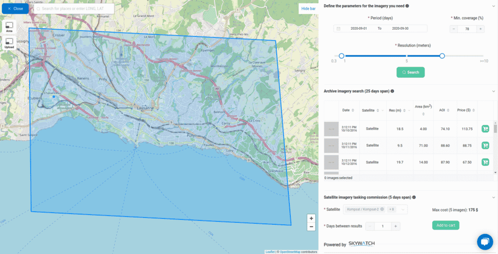
A screenshot of the Picterra platform showing a basemap with options to purchase satellite imagery over a selected area, thanks to Picterra’s partnership with SkyWatch.
Simplifying access to Earth observation data for our users
“Many of our users rely on satellite imagery for monitoring purposes: evaluating the progress of a construction site, monitoring road traffic, or detecting changes in forests are all real-life examples where being able to obtain regular images is incredibly important”, mentioned Stéphane Restani, Senior Software Engineer at Picterra
“In the past, acquiring satellite data was always a very manual process with lengthy emails back-and-forth. The process also required some knowledge about the realm of satellite data and how to search through the various providers”, continued Stéphane.
“Having a single point of entry to search for and buy images on all major satellite imagery providers was incredibly helpful in enabling our users get access to the data they need. Since we are offering a SaaS platform, EarthCache™ enables us to automate and streamline most of the satellite data acquisition pipeline which helps lower costs, reduce friction for the users and improve timely delivery of satellite data.“
Favourite feature: Satellite tasking, on-demand.
“Being able to task a satellite to capture images over a repeating period of time enables a whole new field of possibilities. Our users can now get up to daily updates on their area of interest, and have our ML models crunch the data into actionable insights.”
ABOUT PICTERRA
Established in Lausanne, Switzerland
Founded in 2016
Development team size: 5


