If you manage pipelines, transmission lines, rail corridors, dams, or any other linear or distributed asset, you already know the core tension: the asset never stops, but your visibility does. A ground crew can only be in one place at a time, and by the time a problem is visible from the road, it’s often already a problem. Remote imagery closes that gap, but the moment you start shopping for it, you hit a fork in the road: satellite, aerial, or drone?
The honest answer is that this is the wrong question to ask in isolation. Each altitude solves a different part of the monitoring problem, and the best infrastructure programs use all three. This guide breaks down what each is good for, where each falls short, and how to build a single monitoring workflow that draws on the right source at the right time.
The problem: static inspection can’t keep up with living infrastructure
Traditional infrastructure inspection is episodic. You schedule a flight, dispatch a crew, or send a drone team, capture a snapshot, and file the report. That model has three structural weaknesses. It’s periodic, so anything that happens between inspections is invisible until the next cycle. It’s expensive to repeat, so cadence is driven by budget rather than by risk. And it’s fragmented, so the aerial vendor, the drone contractor, and the satellite archive rarely live in the same workflow.
The shift underway across the industry is from static maps to continuous monitoring. From periodic snapshots to a standing question: “tell me when this asset changes.” Answering that question well is less about any single imagery source and more about combining them intelligently.
Satellite, aerial, and drone: what each altitude is actually for
Satellite imagery: breadth, cadence, and monitoring at scale

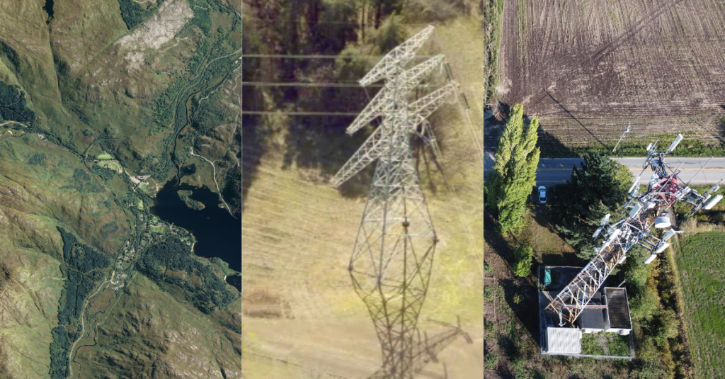
Satellite is the backbone of continuous monitoring. It covers vast areas on a repeating schedule, reaches remote and hard-to-access corridors without mobilizing a crew, and, critically, includes radar (SAR) sensors that see through cloud and darkness. That makes satellite the natural first line for wide-area surveillance: detecting encroachment along a right-of-way, spotting new construction near a pipeline, flagging vegetation growth under transmission lines, or catching ground movement around a dam. Resolution has climbed steadily, with commercial optical now reaching the sub-half-meter and even 15 cm-class range, which is enough to detect and prioritize most change events even if not to resolve fine detail.
Where satellite falls short: for the very finest detail, like a hairline crack, a corroded bolt, or a specific insulator, you usually need to get closer.
Aerial imagery: high resolution over meaningful areas

Aerial imagery (crewed aircraft) sits in the middle. It delivers higher resolution than most satellites over a defined area, with flexible scheduling and strong performance for corridor mapping, orthomosaics, and periodic high-detail sweeps of a full asset. It’s the right tool when you need better-than-satellite detail across a region that’s too large to walk with a drone, like a full transmission network across a county, say, or a long rail segment.
Where aerial falls short: it requires mobilization, weather windows, and airspace coordination, so it isn’t well suited to daily cadence or instant response.
Drone imagery: ultra-high detail, on demand, up close

Drones deliver the finest resolution of all, on your schedule, right up against the asset. When wide-area monitoring flags an anomaly, a drone is how you investigate it: inspecting a specific tower, capturing thermal signatures on a substation, modeling a defect in 3D. Drones are the diagnostic layer: precise, close, and fast to deploy at a single site.
Where drones fall short: limited range and endurance, per-site operational overhead, and regulatory constraints make them impractical for continuous, wide-area coverage. A drone is a scalpel, not a dragnet.
The solution: a tiered, multi-altitude monitoring workflow
Put the three together and a clean operating model emerges: one that maps altitude to job:
Detect (satellite)
Run wide-area, repeating surveillance across the whole asset footprint. Use optical where skies are clear and SAR where they aren’t, so coverage doesn’t collapse on cloudy days. The job here is to flag change, not to resolve it.
Confirm (aerial)
When satellite flags a region of interest, or on a scheduled high-detail cadence, use aerial to capture higher-resolution imagery across the affected corridor and separate real issues from noise.
Diagnose (drone)
For a confirmed problem at a specific site, deploy a drone for ultra-high-resolution, thermal, or 3D inspection to characterize the defect and inform the fix.
This is the difference between a static map and a monitoring program. Satellite gives you persistence and reach; aerial gives you regional detail; drone gives you diagnostic precision. Each covers the others’ blind spots. And because satellite includes both optical and radar, the wide-area layer stays reliable in exactly the conditions, such as cloud, smoke, and night, when infrastructure risk tends to spike.
The real bottleneck: procurement, not pixels
Here’s what usually derails a multi-altitude program. It isn’t the imagery. It’s the plumbing. Teams end up with a separate contract for satellite tasking, another for aerial, a drone contractor on the side, and three different portals, formats, and invoices. The data that’s supposed to inform one decision arrives in three silos. Fragmented procurement, not image quality, is what keeps most monitoring programs stuck in snapshot mode.
Solving that is about access and integration, not about owning any single sensor. The goal is one point of access to many providers across all three altitudes, with procurement, usage, and storage in one place, with the imagery landing directly in the GIS and systems your team already uses.
How SkyWatch fits into an infrastructure monitoring workflow
SkyWatch is the vendor-agnostic gateway to satellite, aerial, and drone imagery across 400+ sensors, built precisely so infrastructure teams don’t have to stitch the plumbing together themselves.
The result is a monitoring workflow where satellite, aerial, and drone reinforce each other instead of living in silos, and where no single sensor, and no single vendor, becomes a single point of failure.
Choosing your data source: a quick reference
- Wide-area, repeating surveillance across a whole asset footprint? Start with satellite (optical + SAR).
- Higher detail across a defined region, on a schedule? Add aerial.
- Ultra-high detail at a specific site, on demand? Send a drone.
- Coverage you can rely on in cloud, smoke, or darkness? Make sure radar is in the mix.
A program that uses all of the above without three separate contracts? That’s the access problem that SkyWatch is built to solve.
Start building your monitoring workflow
Infrastructure doesn’t wait for the next inspection cycle, and neither should your visibility. Explore multi-provider imagery across satellite, aerial, and drone, run it all through one procurement and storage workflow, and bring it straight into your GIS. Start with SkyWatch to see what’s available over your assets today, or talk to us about wiring continuous, multi-altitude monitoring into the tools your team already uses.