SkyAI Is Live: Find, Order and Manage Satellite Imagery Using Natural Language
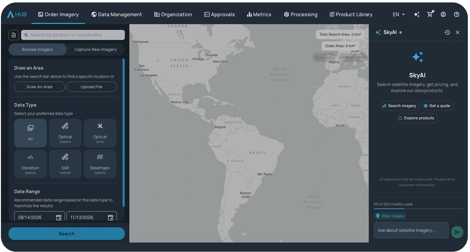
SkyAI is our AI agent, built into SkyWatch applications. Ask for what you need and see the results right on the map. 56 tools, nothing to set up.
- 56Tools in SkyAI
- 700+Sensors and data sources
- ~95%Of commercial imaging satellites
SkyAI is now live in EXPLORE and HUB. It lets you find, order and manage satellite imagery using natural language, right next to the map. SkyAI is on by default for every SkyWatch customer regardless of their role, so there’s nothing to install or connect.
Ask something like “Show me recent clear imagery along the boundary of our mine site,” and SkyAI finds the site, draws the area on the map and shows matching imagery there.
What is SkyAI?
SkyAI is SkyWatch’s AI agent, built into SkyWatch applications, starting with EXPLORE and HUB, with more SkyWatch applications to follow. It works directly with the SkyWatch Platform through 56 tools for finding, buying and using satellite imagery.
Because SkyAI is integrated in the application, it can move through the interface for you. You don’t need an AI assistant of your own.
Through the SkyWatch Platform, SkyAI gives you access to 700+ sensors and data sources, including about 95% of commercial imaging satellites, with one consistent way to search, order and task across them.
What can you do with SkyAI?
You can search, price, order, monitor, and analyze satellite imagery from the SkyAI panel in EXPLORE and HUB. Each capability works with a natural language request:
| Capability | What it covers | Example request |
|---|---|---|
| Discovery and pricing | Search the archive, compare products, estimate cost, check if a new capture is possible | “Show me recent clear imagery along the boundary of our mine site.” |
| Ordering and tasking | Order archive imagery or a new capture, cancel, approve or reject orders | “Can a satellite capture our Iowa farm next month at 50 cm? Book it if it fits our budget.” |
| Budgets and spend | Check remaining budget, see monthly spend, scope orders to a project | “Do we have enough budget on PO #1234 for a monthly tasking of the Ontario mine?” |
| Saved sites and monitoring | Save sites, check for new imagery since you last looked, schedule recurring captures | “Show me any new imagery of the mine site since I last checked.” |
| Analysis and sharing | Run processing on delivered imagery, compare images, share results with your team | “My Houston order arrived. Compare it with January’s image and share a viewer link with my team.” |
| Publishing | Publish finished imagery to ArcGIS Online as a tile layer | “Publish the imagery of the new Bills Stadium as a tile layer into my ArcGIS Online account.” |
How can you use SkyAI?
Here’s how an operations team at a mining company might check for activity along a site boundary, order imagery and keep an eye on the site, all from the SkyAI panel.
- Ask for imagery. Ask for recent clear imagery along the site boundary.
- See it on the map. SkyAI finds the site, draws the area on the map and shows matching imagery there.
- Compare options. Ask to compare two images, and SkyAI opens their details side by side.
- Order against the project. Ask SkyAI to order the image against the project. It checks the project budget and places the order, following your role and the organization’s approval settings.
- Keep watching the site. Ask SkyAI to monitor the site. You can set filters and create a monitored area to get notified when new imagery is available.
How do you get started with SkyAI?
SkyAI is already built into SkyWatch applications, so getting started takes three steps.
Sign in to EXPLORE or HUB
Use your SkyWatch account. Every SkyWatch customer with any role has SkyAI.
Open SkyAI
Open the SkyAI panel in EXPLORE or HUB. There’s nothing to install or connect.
Ask
Type your request in plain language and see the results on the map.
How does SkyAI handle ordering and permissions?
SkyAI places orders directly when your role allows it, without a separate confirmation step. Every order stays within the roles and permissions set up in your SkyWatch account, including project access, budgets and approvals. If an organization requires approvals, SkyAI places the order and readies it for approval, the same way HUB does.
Because SkyAI can only take actions your role allows, the roles and permissions your admins set up are what keep spending in check.
Your roles. Your budgets. Your approvals. Applied to every request.
Who is SkyAI for?
SkyAI is for anyone who works in EXPLORE or HUB, whether they order imagery every day or only occasionally.
Everyday EXPLORE and HUB users
People who order and manage SkyWatch data in EXPLORE and HUB can get to results faster by asking, with everything shown alongside the map.
Teams without an AI assistant
SkyAI works without an AI assistant of your own, which matters when your company hasn’t adopted one or restricts connecting outside tools.
New and occasional users
SkyAI opens the right screens and walks you through workflows, so you don’t have to learn EXPLORE or HUB before you can use it.
Admins and budget holders
Ask about budgets, spend and pending approvals in plain language, with your team’s roles and permissions applied.
What should you do now?
- Open the SkyAI panel in EXPLORE or HUB. It’s already on for every SkyWatch customer, regardless of their role.
- Be specific in your request. Name the place, the timeframe, your budget and how much cloud you can accept.
- Check your team’s roles and permissions. SkyAI orders directly when a role allows it, so make sure project access, budgets and approvals are set up the way you want.
- Save the sites you care about. Then ask for new imagery since your last check, or schedule recurring captures.
Frequently asked questions
What is SkyAI?
SkyAI is SkyWatch’s AI agent, built into SkyWatch applications, starting with EXPLORE and HUB. You describe what you need in plain language, and SkyAI finds, orders and manages satellite imagery on the SkyWatch Platform, showing results right on the map.
Who can use SkyAI?
Every SkyWatch customer can use SkyAI regardless of their role. What SkyAI can do for you follows your role, so it can only take actions your role allows.
Do I need to turn SkyAI on?
No. SkyAI is on by default in EXPLORE and HUB. Open the SkyAI panel and start asking.
Do I need my own AI assistant to use SkyAI?
No. SkyAI is built into SkyWatch, so all you need is your SkyWatch account. There’s nothing to install or connect.
What can SkyAI do?
SkyAI has 56 tools covering search, pricing, ordering, approvals, budgets, saved sites, monitoring, analysis and publishing to ArcGIS Online. Inside EXPLORE and HUB, it can also open the right screens, draw areas on the map and walk you through workflows.
Does SkyAI ask before placing an order?
No. When your role allows ordering, SkyAI places the order directly, without a separate confirmation step. Every order stays within the roles and permissions set up in your SkyWatch account, including project access, budgets and approvals.
Do my company’s roles and permissions apply to SkyAI?
Yes. SkyAI respects the roles and permissions set up in your SkyWatch account, including project access, budgets and approvals, the same way HUB does.
How does site monitoring work in SkyAI?
You can save a site, then ask SkyAI for any new imagery since you last checked. You can also schedule recurring captures of a site, such as a monthly tasking.
What satellite imagery can I access with SkyAI?
SkyAI gives you access to the SkyWatch Platform: 700+ sensors and data sources, including about 95% of commercial imaging satellites.
Can SkyAI publish imagery to ArcGIS Online?
Yes. Ask SkyAI to publish finished imagery to your ArcGIS Online account, and it’s added as a tile layer.
Is SkyAI available in other SkyWatch applications?
SkyAI is built into SkyWatch applications, starting with EXPLORE and HUB, with more SkyWatch applications to follow.
Do I need to be a GIS expert to use SkyAI?
No. You describe what you want in plain language, and SkyAI handles the search, ordering and follow-up steps, guiding you through the workflow as you go.
Try SkyAI in EXPLORE and HUB
Sign in to HUB or EXPLORE, open the SkyAI panel and ask for imagery of a place you care about.