SkyWatch Collaborates with Microsoft to Integrate Commercial Satellite Imagery into Planetary Computer Pro
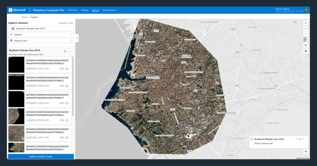
SAN FRANCISCO, CA, UNITED STATES, June 2, 2026 /EINPresswire.com/ — SkyWatch today announced an integration between SkyWatch’s commercial Earth observation platform and Microsoft Planetary Computer Pro; giving enterprise customers a direct path from imagery procurement to analytics. The Microsoft Planetary Computer Pro integration was developed jointly with the Microsoft Planetary Computer engineering team and is built on the SpatioTemporal Asset […]
Spexi Orthomosaic Drone Imagery Now Available on the SkyWatch Platform

KITCHENER, ON / ACCESS Newswire / February 17, 2026 /
SkyWatch and Nearmap Partner to Expand Access to High-Resolution Aerial Imagery for GIS Professionals

KITCHENER, ON / ACCESS Newswire / January 14, 2026 / SkyWatch, a leading geospatial data platform that simplifies access to premium satellite and aerial imagery, today announced a partnership with Nearmap, a global leader in property intelligence. Together, SkyWatch and Nearmap are expanding how geospatial professionals discover, purchase, and use up-to-date aerial imagery to support […]
Spexi and SkyWatch Partner to Bring First-Ever Standardized Drone Imagery to Esri and SkyWatch Users

Spexi is the only provider to offer standardized drone imagery at scale in North America through the SkyWatch platform and Content Store. KITCHENER, Ontario, November 3, 2025 (Newswire.com) – Spexi, the platform behind North America’s largest and fastest-growing standardized ultra-high-resolution drone imagery network, today announced a partnership with SkyWatch, the world’s leading geospatial data aggregation platform. Spexi […]
Eagleview and SkyWatch Announce Alliance to Expand Access to Ultra High-Resolution Aerial Imagery
New collaboration brings Eagleview’s industry-leading imagery to the SkyWatch platform, including Esri’s Content Store for ArcGIS, for single image purchases. KITCHENER, Ontario, July 15, 2025 (Newswire.com) – Eagleview, a leading provider of aerial imagery and analytics, and SkyWatch, a leader in remote sensing data technology, today are announcing a new collaboration that makes Eagleview’s ultra high-resolution aerial […]
Esri Launches Content Store for ArcGIS
REDLANDS, Calif.–(BUSINESS WIRE)–Esri, the global market leader in location intelligence, is launching Content Store for ArcGIS, a new web app that simplifies the process of purchasing and integrating commercial satellite imagery. This app, developed by Esri and SkyWatch, allows organizations to buy high-quality imagery from Esri’s cornerstone partner, Maxar, as well as other leading providers. […]
Maxar Imagery is now Available on the SkyWatch Platform

WATERLOO, Ontario and WESTMINSTER, Colo., October 9, 2024 (Newswire.com) – SkyWatch, a leading provider of commercial geospatial data, and Maxar, the leading provider of secure, precise geospatial intelligence, today announced a multi-year agreement enabling the distribution of Maxar’s high-resolution satellite imagery to SkyWatch’s global customer base* via the SkyWatch platform. Through this partnership, SkyWatch customers will have […]
SkyWatch Relaunches SkyWatch HUB with Expanded Enterprise Features

SkyWatch HUB, formerly known as EarthCache Enterprise, now offers additional functionality built especially for organizations that need to manage and control large amounts of geospatial data across the enterprise. Stuttgart, GERMANY, ON – [Date] – SkyWatch, a leading provider of geospatial data solutions, announced today at INTERGEO the relaunch of SkyWatch HUB, now featuring an […]
Scribble Maps Integrates Earth Observation Data With SkyWatch BUILD

TORONTO, August 28, 2024 (Newswire.com) – Scribble Maps, a leading online mapping tool known for its user-friendly interface and robust feature set, is thrilled to announce the successful integration of Earth observation data into its platform. This enhancement, powered by SkyWatch’s BUILD application, brings a new dimension of geospatial intelligence to Scribble Maps, enabling users […]
SkyWatch Announces Content Store for ArcGIS

The new web application is built on, and deeply integrated with, Esri’s ArcGIS Online platform to provide a premium experience for geospatial content discovery and purchase. SAN DIEGO, July 16, 2024 (Newswire.com) – SkyWatch Space Applications Inc. (“SkyWatch“), a leader in the geospatial data technology industry, announced today, at the Esri User Conference, SkyWatch Content […]