Access to clear, precise geospatial data is completely changing how organizations work. For industries like mining, energy, government, and urban development, the ability to see our planet in amazing detail is a game-changer. Leaders can now make smarter, faster decisions that improve compliance, safety, and operational efficiency. Thanks to incredible advancements in technology, today’s highest resolution satellite imagery sets a new standard for both detail and accessibility.
Let’s explore the world of satellite imagery resolution. This guide will help you confidently choose the best data for your next project.
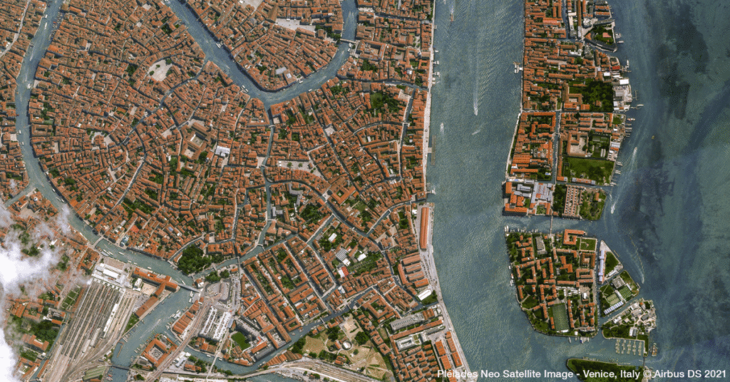
Understanding the Highest Resolution Satellite Imagery
To unlock the full potential of this technology, it’s important to understand what resolution means. Resolution is measured in centimeters (cm) or meters (m). It tells you the real-world size represented by a single pixel in an image. As technology improves, the highest resolution satellite imagery becomes even more detailed.
Here is how the industry categorizes the latest offerings:
- Ultra High Resolution (≤15cm): First, we have imagery at 15 cm per pixel or finer. This unprecedented level of detail allows you to see small surface features. For example, you can closely monitor construction equipment or inspect assets with near-aerial quality. This is the absolute highest resolution satellite imagery available today.
- Very High Resolution (16–49cm): Next, imagery in this range, such as 30 cm or 40 cm, reveals vehicles, individual people, and small environmental changes. It also shows infrastructure components with great clarity. Consequently, this is the gold standard for applications that need sharp precision.
- High Resolution (50–99cm): This resolution is clear enough to distinguish between buildings, roads, and large vegetation. In addition, you can easily see reference points like property boundaries and field edges. Therefore, it’s ideal for mapping, planning, and compliance.
- Medium Resolution (1–7.99m): Furthermore, this tier is excellent for monitoring larger regions or tracking environmental shifts. It’s also perfect for managing agricultural resources. You will see broad landscape patterns and wide-area changes.
- Low Resolution (8m+): Finally, low resolution is best for large-scale land use and climate monitoring. It is used when granular features are not needed, but broader trends are vital for regional change detection.
Why Finding the Highest Resolution Satellite Imagery For Your Project Matters
Different resolution levels support different business goals. Each tier provides unique advantages for specific tasks. For instance, a project manager overseeing a construction site needs a different level of detail than an environmental scientist studying deforestation. Here’s how organizations use these categories to achieve their objectives.
Ultra High Resolution Applications (≤15cm)
When you need the absolute finest detail, the highest resolution satellite imagery delivers.
- Urban Infrastructure: You can inspect individual rooftops, assess storm damage with precision, or even count vehicles on a street. Moreover, it allows you to monitor progress on construction sites down to the smallest detail.
- Asset Management: This resolution is perfect for tracking small assets and spotting encroachment near sensitive equipment. It also helps you evaluate site safety with a level of precision that was once only possible with aerial surveys.
Very High Resolution Applications (16–49cm)
This category provides an excellent balance of detail and coverage area for many critical tasks.
- Compliance & Reporting: You can detect minor land-use changes and verify environmental restoration projects. In addition, it helps create highly accurate audit trails for regulatory bodies, ensuring you meet all requirements.
- Disaster Response: After an emergency, this imagery allows teams to rapidly identify impacted structures, routes, and resources. As a result, it supports more effective planning and recovery efforts.
High Resolution Applications (50–99cm)
High resolution is a reliable choice for large-scale planning and analysis.
- Planning & Design: This resolution is ideal for engineering, utilities, and urban planning teams. They need reliable maps of buildings, transportation networks, and public spaces to design future projects effectively.
- Regional Analysis: You can compare land use patterns over time, monitor utility corridors, or track infrastructure development across entire city blocks or suburban areas.
Medium Resolution Applications (1–7.99m)
For monitoring vast areas, medium resolution offers incredible value.
- Agriculture & Forestry: This imagery helps optimize crop management and monitor reforestation projects. It can also be used to assess the health of vast landscapes, providing key insights for resource management.
- Environmental Monitoring: It allows scientists to spot large-scale changes like deforestation, wetland loss, or seasonal land variations, which helps in conservation efforts.
Low Resolution Applications (8m+)
When you need a view of the bigger picture, low resolution is the perfect tool.
- Climate Research: Researchers use this data to monitor entire ecosystems, track regional droughts or floods, and assess landscape-scale transformations over long periods.
- Strategic Planning: This resolution supports national or international initiatives focused on resource allocation, conservation, and land stewardship.
How to Access the Highest Resolution Satellite Imagery
Getting the right resolution for your project is easier than ever before. Modern platforms provide simple and powerful ways to acquire data.
You can now:
- Search Trusted Archives: Instantly find and purchase historical or recent imagery in your required resolution through SkyWatch. Intuitive, self-serve interfaces make the process quick and easy.
- Task Satellites On-Demand: For time-sensitive or custom needs, you can instruct satellites to capture new imagery. You can specify the exact resolution and the area you need covered.
- Integrate Seamlessly: Download your data directly into your GIS or analytics platform. This streamlines your workflows and accelerates your path from a question to a data-driven answer.
Modern providers, including those in the SkyWatch marketplace, deliver transparent and flexible options across all these categories. Whether you need the highest resolution satellite imagery for detailed asset inspections or medium-resolution data for watershed monitoring, you can optimize your investment by paying only for what you need.
The Future is Clear: Elevate Your Projects with the Right Data
Choosing the right satellite image resolution is about finding the perfect balance between detail, area, speed, and cost. With so many options available—from ultra-high to low resolution—there has never been a better time to use geospatial data for smarter, faster decision-making.
Unlock the full potential of your next project by selecting the imagery that aligns perfectly with your goals. As satellite technology continues to evolve, organizations equipped with the right data are set to build a more precise, efficient, and sustainable future from above.