Trick question: it depends on what you are trying to do.
What does resolution mean?
The resolution of Earth observation data is determined by three factors: spatial resolution, spectral resolution, and temporal resolution. While all three have to be considered when looking at satellite data, most people mean “spatial resolution” when they ask about resolution.
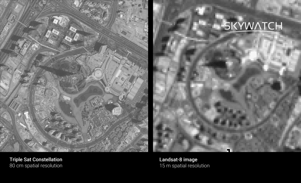
Spatial resolution is the size of one pixel on the ground. A pixel is a block of information representing the smallest individual element of an image. Pixels are called ‘picture elements.’ If each pixel represents a 30 x 30 cm area, for optical data, you would be able to distinguish details such as cars or houses at a finer spatial resolution, such as 30 cm. In a digital image of the same size with a coarser resolution, a larger area of Earth would be covered, and smaller features would be more difficult to distinguish.
SkyWatch SAR expert’s note: The above definition only applies to optical data. Synthetic aperture radar (SAR) data is acquired at a slant rather than nadir, so pixels on the ground are not square.
To illustrate better, here are two satellite images of the same location (Burj Khalifa, Dubai) that have been taken with different spatial resolution sensors. On the left is a 30 cm resolution from Triple Sat Constellation, and on the right is a 15 m resolution from Landsat-8. In this side-by-side comparison, the Triple Sat Constellation imaged the Burj Khalifa at a resolution of 30 centimetres and Landsat-8 imaged it at a resolution of 15 meters. Due to the coarser resolution, it is difficult to distinguish small features on the ground, such as roads, trees, and buildings.

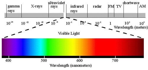
Spectral resolution is related to the granularity of the breadth of coverage of the electromagnetic spectrum captured by the satellite sensors. A finer spectral resolution can discriminate between narrower bands of wavelength, differentiating, for example, between red, green, and blue bands and allowing for coloured images.

Satellite sensors can capture data that would be invisible to the naked eye, and a higher spectral resolution can provide us with a different view of objects and landscapes. For example, the shortwave infrared ranges enable highly effective geological mapping because rocks and minerals have their own spectral pattern in these bands.
Temporal resolution refers to the time elapsed between viewings of the same area on Earth at the same angle. It can range from continuous coverage for geostationary platforms – such as a weather satellite; set at a fixed point over the Earth’s surface – to several days between revisits for low earth orbiting platforms (LEO). A higher temporal resolution means a shorter revisit time.
WHAT RESOLUTIONS ARE AVAILABLE IN 2023?
The spatial resolution of Earth observation satellites in the early 1980s was around 80 meters – as Landsat-4 had. You can now purchase satellite data with spatial resolutions as low as 15 centimetres. With some of the finer sensors, you can get images with a resolution of 10 meters for open data.
Since sensors were refined and more bands became available for study, the spectral resolution has dramatically improved over the past few decades. Some of the most recent satellite sensors can now capture information on over 1,000 different spectral bands.
In terms of temporal resolution, it still varies greatly between satellites. Nevertheless, if you are interested in data regarding one particular area, the sheer number of satellites has increased your chances of obtaining multiple, non-cloudy, usable images. Launching many smaller satellites into orbit has significantly increased the satellite coverage of the earth, making it much easier to acquire satellite imagery quickly.
HOW TO DECIDE WHICH SPATIAL RESOLUTION YOU NEED
The most detailed spatial resolution may not always be the best when analyzing remote-sensing data or creating a space app. Think first about what you are trying to achieve and what resolutions you need to solve a business problem.
For example, a consortium led by the Joint Research Centre (JRC) has successfully combined data from multiple coarser resolution satellites to monitor forest fires, using each satellite to compensate for the deficiencies of the other – Sentinel-2’s cloud perturbation sensitivity and Sentinel-1’s ground moisture sensitivity.
The continuous improvement of sensors, coupled with the increasing amount of available satellite data, has led to a dramatic expansion of applications for satellite imagery.
Read our Ultimate Satellite Imagery Guide for more information on understanding what resolution you need for your next project.


