Design and Implement Sustainability Strategies With Satellite Data

52impact brings spatial (satellite, aerial, and drone) information to markets who haven’t been using these types of datasets. The company is working with decision makers in industries who haven’t previously worked with geospatial data. The group leans heavily on close customer relations and data visualization to help bridge the gap between the images and the […]
AI in Space

AI in space is not just for government officials or the military; it’s available to anyone looking to access it. At SkyWatch, we believe in simplicity. We’ve taken a very challenging data engineering problem – obtaining, processing, and standardizing satellite data – and built a platform that abstracts the massive amount of complexity required to […]
Understanding data transfers
Let’s break down data transfers. Satellite data collection is extensive, with some of the latest high-resolution optical and radar readings gathering gigabits of information each second. The issue lies in sending this data back to Earth, an act known as a downlink. Unfortunately, current technology has these downlinks occurring on sun-synchronous orbits at limited points […]
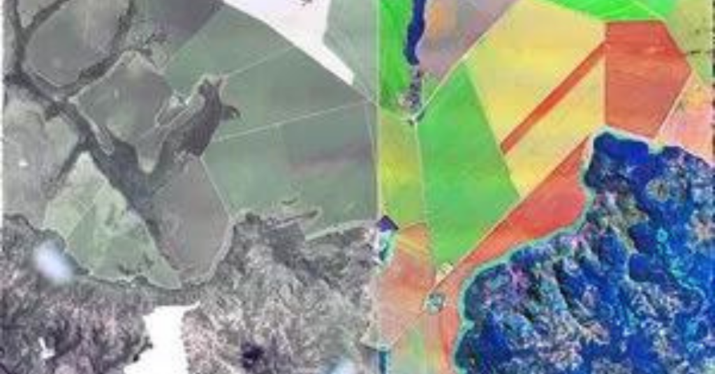
Understanding how Satellite Images are created

Understanding how satellite images are created begins with sensors. Satellite sensors, unlike our eyes, capture much more information and relay it back to us in a format quite different from the photographs we are used to. Satellites capture data by assigning a digital value to each pixel based on the reflectance of the corresponding area […]
Understanding Orbits

Sun-synchronous low Earth orbits Understanding orbits is simpler than one might think. In the same way as consumer cameras, the closer you are to the object you want to capture, the more details you can see. Satellites in Low Earth Orbit (LEO) can capture images of high resolution because they are closer to the object […]
What’s the difference between multispectral, hyperspectral, and SAR?
Multispectral and hyperspectral satellites A sensor’s spatial resolution, or how fine the pixels on the ground will be, is inversely related to its spectral resolution or how well it can discriminate between spectral bands. Because of this, satellites that record data along multiple spectral bands (hyperspectral) do not have the same spatial resolution as satellites […]
How an infrastructure company uses satellite data

LiveEO uses satellite imagery to provide innovative infrastructure monitoring in the verticals railway, electricity, and pipelines and empowers the operators to save in operational expenses by observing dangers from vegetation, height changes and third party interactions along the network. How LiveEO uses satellite data Sven Przywarra, LiveEO’s co-founder explained that the company focuses on generating […]
How an Artificial Intelligence company uses satellite data

Picterra is a self-serve platform enabling businesses to autonomously extract intelligence & analytics from satellite, aerial, and drone imagery. It comes with a ready-to-use IT infrastructure: in a few clicks, it’s possible to process terabytes of imagery with Picterra’s auto-scaling, GPU-enabled infrastructure. With Picterra, a machine learning model can be built in less than 30 […]
SkyWatch Signs Agreement with Guyana-Based Latitude Geospatial
WATERLOO, ONTARIO, June 18, 2021 – Latitude Geospatial Consulting Inc. (“LatGeo”), a Guyana-based geospatial data partner and location technology consultancy, has been selected by SkyWatch Space Applications Inc. (“SkyWatch), to deliver Earth observation data in Guyana. LatGeo provides creative solutions in the areas of location-based technologies and location-based intelligence, using GIS services and spatial data. […]
5 Benefits of Using Satellite Imagery Over Drones

According to Euroconsult, the global market for commercial Earth observation data and services will reach $8 billion by 2029, up from $4.6 billion in 2019. Understanding when to use satellite imagery over drones is key to making an informed decision when collecting this data type. Here are 5 benefits of using satellite imagery over drones […]