At SkyWatch, we’re on a mission to make Earth observation data more accessible, discoverable, and useful than ever before. That’s why we’re excited to announce that high-resolution aerial imagery from leading providers is now available directly through SkyWatch’s Content Store for Esri ArcGIS.
Content Store makes it easy for ArcGIS users to browse, preview, and purchase premium Earth observation data right within their familiar Esri environment, eliminating the need to leave ArcGIS to find, license, and import imagery.
Access World-Class Aerial Imagery Providers
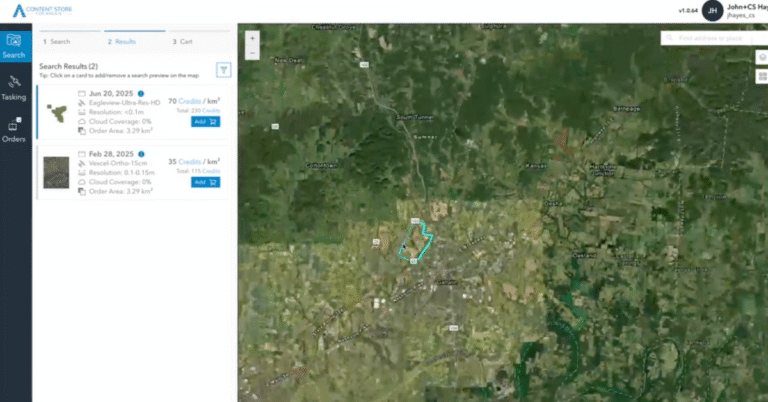
Content Store now includes data from two of the world’s leading aerial imagery providers: Eagleview and Vexcel.
With both Eagleview and Vexcel now integrated into Content Store, ArcGIS users can seamlessly access premium aerial imagery alongside satellite data, all within one unified experience.
Eagleview
Eagleview brings decades of experience in aerial imaging, offering ultra-high-resolution orthomosaic and oblique imagery across the United States. With sub-5 cm resolution and precise geospatial accuracy, Eagleview’s frequently updated data supports use cases from insurance and real estate to utilities, construction, and public safety.
Vexcel
Vexcel delivers a global aerial library covering more than 40 countries, captured with professional-grade camera systems that produce sub-10 cm resolution imagery. Their consistent, high-quality data is trusted for urban planning, infrastructure monitoring, environmental analysis, and more.
More to Look Forward To
We’re also working to bring Nearmap imagery to Content Store soon. Nearmap’s extensive coverage and frequently updated aerial data will make it even easier for ArcGIS users to access the most current, detailed imagery available.
A Unified Earth Observation Experience for ArcGIS Users
By bringing aerial imagery into Content Store for ArcGIS, we’re bridging the gap between satellite and aerial data, empowering users to access the exact level of detail they need, when they need it. Whether you’re assessing property conditions, planning infrastructure, or monitoring environmental change, Content Store gives you instant access to the imagery that drives better decisions.
Explore Content Store for ArcGIS today and see how easy it is to integrate premium aerial data into your workflows.