
The view from above is changing how we do business. Satellite imagery and remote sensing, collectively known as Earth observation (EO) data, are no longer just tools for spies or meteorologists. Today, hedge funds use them to count cars in retail parking lots, insurance companies use them to assess flood risk, and farmers use them to monitor crop health.
However, access to data doesn’t automatically equal insight. Many organizations rush to acquire these high-tech datasets without a clear plan, leading to wasted budgets and confusing results. It is easy to get lost in the sheer volume of pixels and spectral bands if you don’t know exactly what you are looking for.
This guide explores the most frequent stumbling blocks business users face when integrating EO data into their workflows. We will break down why these mistakes happen and, more importantly, how you can sidestep them to get real value from your investment.
Mistake 1: Assuming Higher Resolution Is Always Better
One of the first things a business user asks for is “the best resolution possible.” It seems intuitive. If you are buying a TV, you want 4K or 8K. Why would satellite imagery be different?
The reality is that spatial resolution (the size of the smallest object you can distinguish on the ground) comes with trade-offs. Extremely high-resolution imagery (like 15cm per pixel) is expensive. It also creates massive files that are slow to process and store.
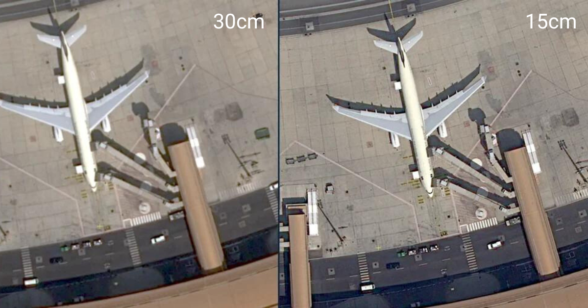
The Solution: Match Resolution to the Use Case
You don’t need to count the rivets on a ship if your goal is simply to track the ship’s movement.
For broad monitoring: If you are monitoring deforestation across a state or tracking regional ice melt, medium-resolution data (like 10m-30m) is often free (thanks to programs like Sentinel or Landsat) and perfectly adequate.
For site-specific analysis: If you need to inspect infrastructure damage on a pipeline or count individual shipping containers, then paying for high-resolution commercial data makes sense.
Start with the problem you are solving, not the technology. Define the smallest object you need to identify. If it is a house, you don’t need data capable of seeing a mailbox.
Mistake 2: Ignoring Temporal Resolution (Revisit Rate)
Business users often focus so much on what they can see that they forget when they can see it. A high-resolution image of your supply chain hub is useless if it was taken three months ago. This is where temporal resolution comes in. How frequently does the satellite revisit the same spot on Earth?
Many users purchase a dataset only to realize it doesn’t update fast enough to catch the changes they need to monitor.
The Solution: Define Your Required Frequency
Before you sign a contract, map out the speed of change in your industry.
- Agricultural cycles: Crops change slowly over weeks. A weekly or bi-weekly image is usually sufficient.
- Disaster response: Floods and fires move fast. You need daily or even sub-daily updates.
- Construction monitoring: Monthly updates might be enough to verify progress for billing.
Look for “constellations” of satellites rather than single satellites. Companies like Vantor or Airbus operate fleets that can image the same location daily, ensuring you aren’t looking at stale data.
Mistake 3: Treating Clouds as a Minor Inconvenience
It sounds obvious, but it is the bane of the industry: satellites cannot see through clouds with standard optical cameras. Since about 67% of the Earth is covered by clouds at any given moment, this is a major operational hurdle.
Business users often build models assuming perfect, clear imagery. When the rainy season hits their target area, their data stream goes dark, and their algorithms fail.
The Solution: Diversify Your Sensors
You have two main options here:
- Cloud masking and mosaics: Use software that stitches together clear pixels from multiple days to create a cloud-free image. This works well for static backgrounds (like basemaps) but is bad for tracking real-time activity.
- Synthetic Aperture Radar (SAR): This is the game-changer. SAR sensors send down their own energy pulses and record the reflection. They can “see” through clouds, smoke, and even operate at night.
If your business operation is in a tropical region or requires guaranteed monitoring regardless of weather, you must integrate SAR data into your strategy. Don’t rely solely on optical imagery.
Mistake 4: Underestimating the "Clean-Up" Phase
Raw satellite data is messy. It isn’t a neat JPEG you can just drop into a PowerPoint presentation. It requires significant pre-processing.
Raw data is affected by atmospheric distortion (haze), sensor angles, and terrain elevation. A common mistake is analyzing “raw” data directly, leading to false conclusions. For example, a hill’s shadow might look like water to an untrained algorithm, or atmospheric haze might look like poor crop health.
The Solution: Buy "Analysis-Ready Data" (ARD)
Unless you have a team of geospatial engineers in-house, do not buy raw data. Look for providers who offer Analysis-Ready Data (ARD).
ARD has already been corrected for:
- Atmospheric interference: The haze is removed.
- Geometric alignment: The image is perfectly aligned with maps (orthorectified).
- Sensor calibration: The pixel values represent accurate physical measurements.
Paying a premium for ARD saves you countless hours of engineering time and ensures your analytics are based on reality, not optical illusions.
Mistake 6: Overlooking the "Black Box" Problem with AI
To process the massive amount of EO data, businesses turn to Machine Learning (ML) and Artificial Intelligence (AI). They buy “black box” solutions: algorithms that promise to detect cars, trees, or buildings automatically.
The mistake lies in not understanding how these models were trained. An AI trained to recognize roofs in suburban California might fail miserably when trying to count roofs in rural India because the materials, shapes, and colors are completely different.
The Solution: Ask About Training Data
When working with vendors or building internal tools, ask the right questions:
- “Where was this model trained?”
- “Does the training data represent the geography we are interested in?”
- “What is the false-positive rate?”
Demand transparency. If you are monitoring assets in snowy regions, ensure the AI knows what snow looks like so it doesn’t confuse it with white rooftops or clouds.
Next Steps for Your Data Strategy
Earth Observation data holds incredible potential to uncover hidden trends and optimize operations. But like any powerful tool, it requires skill to use safely.
To avoid these common pitfalls:
- Start small: Run a pilot project on a small geographic area before scaling globally.
- Define success: Know exactly what question you are trying to answer.
- Consult experts: Don’t guess. The geospatial community is collaborative, so leverage consultants or vendor engineers to pick the right data type.
By respecting the complexity of the data and focusing on integration rather than just accumulation, you can turn the view from space into a clear vision for your business. Get started on your EO journey with SkyWatch.