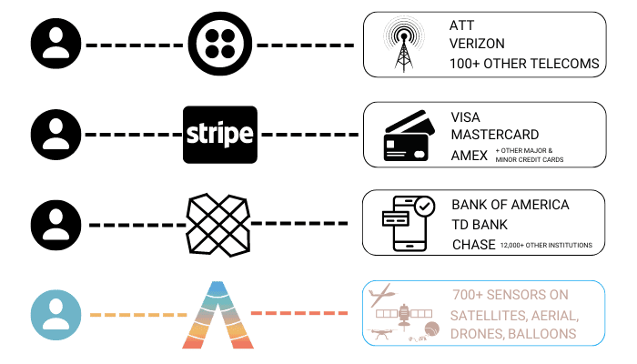
When we started SkyWatch, our vision was to build a platform that enabled anyone to programmatically access all of the world’s satellite data, through a single easy-to-use Application Programming Interface (“API”). We were inspired by what Twilio did for communications infrastructure; what Stripe did for payment processing; and what Plaid was doing for financial services.
At the core, these companies were abstracting massively complex infrastructures (telecom, financial institutions, etc.) with APIs that allowed millions of businesses to leverage them without having to develop an ounce of knowledge as to how the technical infrastructure works. As a result, they unlocked trillions of dollars of value, while accruing billions of dollars of equity value themselves.
It was reasonable to assume that there was an analogous opportunity in the Earth observation market. The hundreds of remote sensing satellites in orbit with unique capabilities, the hundreds of ground stations, the dozens of pricing and licensing models, and the handful of different file formats and standards represented what we believed to be a nearly unrivalled web of complex infrastructure that was massively underutilized.
We believed that if we could abstract this complexity, we could unlock trillions of dollars of economic value (just look at GPS) to the benefit of end users, application developers, data providers, and of course, SkyWatch.
Easier said than done.
The fragmented infrastructure powering the Earth observation market was far more immature than we could have imagined. Customers needed manual vetting; orders required manual reviews; how and when orders were fulfilled was a black box; image processing was manual, and when automated, was not of reliable quality. When you have this much manual intervention, building delightfully seamless programmatic experiences for developers is next to impossible.
Rather than give up on the mission, we took this on as our responsibility to fix. So we started investing in software solutions across the entire value chain. We led the industry with innovations in image processing, tasking optimization, order management, and onboard processing.
We did all of this to power EarthCache and TerraStream, our products that served customers and data providers respectively. However, as we scaled EarthCache to thousands of customers globally, some challenges emerged. You see, we’re dead set on positively impacting as many humans as possible. With this aim in mind, we serve dozens of verticals and hundreds of use cases. And as our customers’ needs became more diversified and niche, we realized we couldn’t address them all effectively through one product.
So, we’re switching gears and doubling down on our original vision.
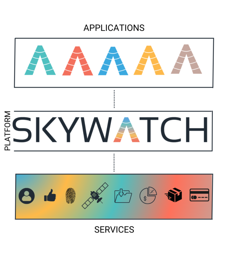
Moving forward, The SkyWatch Platform will be at the core of everything we do. The SkyWatch Platform is a collection of the (formerly internal) services that previously powered our products, but can now be used and leveraged by anyone looking to build or benefit from the future of geospatial data.
The SkyWatch Platform is composed of seven core services which include: Identity, Archive & Tasking, Order, Fulfillment, Payments, Policy, and Location. In our next post, we’ll get into the details of how developers can leverage these services.
For those of you who are not developers, the important takeaway is that the SkyWatch Platform is a set of high-performing modular components that will power applications that are more tailored to your specific needs. With applications more tailored to your needs, geospatial data will be integrated more seamlessly into your everyday life.
And speaking of applications, over the coming days we’ll be diving deep into 5 new applications SkyWatch is building right atop the SkyWatch Platform.
The first is targeted at individual end users whose only requirement is a very simple UX to quickly search for and buy geospatial data.
The second is targeted at developers and those want to programmatically integrate geospatial data into their applications, whether for their own end use or for sale out to their user base.
The third is targeted at organizations, big and small, who need to manage procurement, storage, payment, and sharing across their entire organization.
The fourth is targeted at the users of GIS, enabling them to get the data they need, when they need, right from within their GIS.
The fifth and final application is targeted to organizations selling geospatial data, enabling them to reach hundreds of thousands of users, in nearly every country on the planet, across dozens of channels and paths to market.
These applications, while built by us, are meant to demonstrate the art of what’s possible when building on the SkyWatch Platform. We encourage everyone to take inspiration from them, make better versions of what you see, or build something entirely new.
So, how will you know which application is best suited for you? Along with these new services and applications, we are also introducing new SkyWatch Accounts.
They will be as follows:
BUILD – for developers who want to programmatically integrate geospatial data into their applications or workflow, whether for the purpose of internal use or for selling to a wider audience. Build accounts will start off free but will require a monthly subscription for those of you who want to sell geospatial data.
HUB – for organizations who want to manage procurement, storage, payment, and sharing across your entire organization.
PAYU – this is the default SkyWatch account. When you sign up for SkyWatch, you’ll automatically receive a Pay-As-You-Use (“PAYU”) account, allowing you to purchase data as you need it.
Provider – for organizations that sell geospatial data, whether that be remote sensing imagery, vector data, or anything in between. Provider accounts will come with a two tiers of subscription services, that will allow you to maximize your reach, revenue, and profitability.
There are two more important changes I’d like to draw your attention to. The first, when we talk about data, we are no longer just talking about space-borne Earth observation data. The SkyWatch Platform is now the distribution platform for all geospatial data, whether that be imagery from satellites, drones, or balloons, or non-imagery datasets like land cover classification base maps or human trafficking patterns. If it’s geospatial, it’s on the SkyWatch Platform.
Second, we’re leaning into this identity with a complete rebrand and new logo. SkyWatch’s rebrand preserves its typography and symbolic icon but incorporates a fresh colour scheme to represent our planet and satellite imagery along with electromagnetic waves and remote sensing data synergies. Each application is represented by an independent colour and included in the SkyWatch icon’s gradient.
We know that this is a lot of change, but we truly believe that this is the model that will unlock trillions of dollars of economic value in the geospatial domain.
Most importantly, we’re excited to see what value this unlocks for you.