Industry Leaders Satellogic and SkyWatch Announce Partnership
PARIS, France, September 13, 2023 (Newswire.com) – Satellogic Inc. (NASDAQ: SATL), a leader in sub-meter resolution Earth Observation (“EO”) data collection, and SkyWatch, a leader in the remote sensing data technology industry, announced today, at World Satellite Business Week, their partnership to bring Satellogic’s highest resolution commercially available EO data to EarthCache customers. Satellogic’s EO […]
SkyWatch Announces Availability of Umbra SAR Data
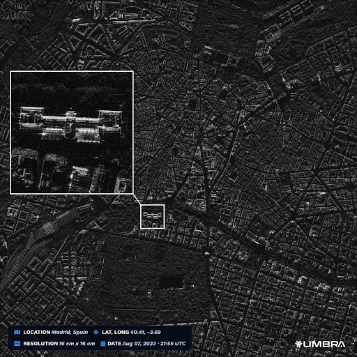
KITCHENER, Ontario, August 16, 2023 (Newswire.com) – SkyWatch, a leader in the remote sensing data technology industry, announced today its partnership with Umbra, a leader in advanced space radar technology. This partnership will allow customers to purchase Umbra’s industry-leading synthetic aperture radar (SAR) data via SkyWatch’s EarthCache platform. SkyWatch’s core mission is to make remote […]
SkyWatch Announces EarthCache Enterprise
KITCHENER, Ontario, July 26, 2023 (Newswire.com) – SkyWatch Space Applications Inc. (“SkyWatch”), a leader in the remote sensing technology industry, today announced the launch of EarthCache Enterprise, which enables organizations to more efficiently source and manage remote sensing data, with rich insights into data usage, expenditures, and performance. SkyWatch is well-known for launching the first API for […]
SkyWatch Announces EarthCache for ArcGIS Pro
KITCHENER, Ontario, May 30, 2023 (Newswire.com) – SkyWatch Space Applications Inc. (“SkyWatch”), a leader in the remote sensing data technology industry, announced today the availability of EarthCache for ArcGIS Pro. This integration makes SkyWatch’s EarthCache platform, which aggregates data from the world’s leading satellite data providers, available to Esri users within ArcGIS Pro, with one […]
Government of Canada Invests in SkyWatch to Build Advanced Autonomous Space Systems
KITCHENER, Ontario, May 1, 2023 (Newswire.com) – SkyWatch Space Applications Inc. (“SkyWatch”), a leader in the remote sensing data technology industry, announced today that it has been selected by the Canadian Space Agency (CSA) to complete Phase 2 of the Artificial Intelligence and Big Data Analytics for Advanced Autonomous Space Systems challenge. This award follows the successful completion […]
SkyWatch Announces Data Distribution Partnership With Urban Sky
KITCHENER, Ontario, April 11, 2023 (Newswire.com) – SkyWatch Space Applications Inc. (“SkyWatch“), a leader in the remote sensing data technology industry, announced today its partnership with Urban Sky, a leading provider of broad area, high-resolution aerial imagery. This partnership will accelerate Urban Sky’s commercial data distribution strategy via SkyWatch’s data management and distribution platform, TerraStream, […]
SkyWatch Announces TerraStream Edge
SkyWatch Space Applications Inc. (SkyWatch) announced today at AWS re:Invent TerraStream Edge, a suite of embedded edge computing software modules for on-orbit satellite computing platforms.
SkyWatch Announces New Offering and New Partnerships
SkyWatch Space Applications Inc. announced today the launch of EarthCache-X (EC-X) and its partnerships with Capella Space, ICEYE, Satellogic, and Vexcel Imaging, to deliver emerging data types to the commercial Earth observation (EO) market.
SkyWatch Announces Two New TerraStream Partnerships
SkyWatch Space Applications Inc. announced today at World Satellite Business Week two new partnerships in the TerraStream ecosystem: Esper Satellite Imagery and Nara Space.
SkyWatch Announces Xplore Data Distribution Partnership
SkyWatch Space Applications Inc., a Kitchener-based space technology startup, and Xplore Inc., a commercial space company providing Space as a Service®, today announced they have signed a partnership agreement.