The EarthCache for Esri ArcGIS Pro add-in enables ArcGIS users to access, manage, and distribute high-quality satellite imagery within ArcGIS workflows.

KITCHENER, Ontario, May 30, 2023 (Newswire.com) - SkyWatch Space Applications Inc. ("SkyWatch"), a leader in the remote sensing data technology industry, announced today the availability of EarthCache for ArcGIS Pro. This integration makes SkyWatch's EarthCache platform, which aggregates data from the world's leading satellite data providers, available to Esri users within ArcGIS Pro, with one single add-in.

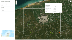
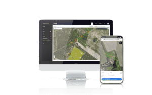
Screenshot of SkyWatch EarthCache application within Esri ArcGIS Pro

The integration of SkyWatch's Earth observation (EO) platform, EarthCache, with ArcGIS Pro not only provides a single aggregate source of EO data from the world's leading satellite and remote sensing operators, but allows users to experience the full capabilities without leaving ArcGIS Pro. SkyWatch's transparent pay-as-you-go pricing model provides ArcGIS Pro users with the ability to access high-quality satellite imagery directly within ArcGIS, without the requirement to maintain commercial relationships with each data provider. Additionally, ArcGIS Pro users have the flexibility to publish to ArcGIS Online, create tiled basemaps from disparate geo-referenced images, and customize how acquired data is saved, shared, and managed.

"The integration of EarthCache with ArcGIS Pro enables Esri users to more efficiently incorporate satellite imagery into their current workflows," says David Proulx, Chief Product Officer at SkyWatch. "This integration demonstrates our commitment to making satellite imagery and other types of remote sensing data more accessible. Esri is the global leader in geographic information systems (GIS) technology and location intelligence, and we're thrilled to partner with Esri to deliver Earth observation data to ArcGIS Pro customers"

The EarthCache for ArcGIS add-in is available now in the Esri ArcGIS Marketplace and at SkyWatch.com.

SkyWatch joined the Esri Partner Network in July 2022.

About SkyWatch
SkyWatch, a space data technology company, is changing the way Earth observation and remote sensing data is managed, distributed and accessed through its data aggregation platform, EarthCache, and its data management and distribution platform, TerraStream. SkyWatch partners with multiple operators and data providers to streamline operations and supply data to geospatial experts and leading organizations looking to bring the power of EO data to their workflows.

SkyWatch was selected by the Canadian Space Agency to receive $1,128,870.00 (taxes included) through the Innovation Solutions Canada program.

SkyWatch Space Applications Inc. ("SkyWatch"), a leader in the remote sensing data technology industry, announced today that it has been selected by the Canadian Space Agency (CSA) to complete Phase 2 of the Artificial Intelligence and Big Data Analytics for Advanced Autonomous Space Systems challenge. This award follows the successful completion of Phase 1, where SkyWatch worked closely with the CSA to develop a proof of concept system to demonstrate the technical feasibility and commercial potential of applying artificial intelligence (AI) and big data analytics across the planning, capture, and delivery of multiple Earth observation missions.

The goal of the Artificial Intelligence and Big Data Analytics for Advanced Autonomous Space Systems challenge is to use AI and big data analytics to optimize the operations and usage of space and Earth observation assets. Earth observation data captured from CSA missions is used across government agencies, and the desired challenge outcomes include "(the minimization of) redundancy between disparate missions imaging the same targets" and "(enabling) autonomous prediction of natural or man-made disasters, which could allow Earth observation platforms to transition from reactionary imaging in response to crises to new services in predicting and preventing disasters, (including fires, floods, disease outbreak, space weather events, etc.)." 

SkyWatch's mandate for Phase 2 is to further advance CSA operations in the areas of mission planning, mission integration with autonomous data management and compliance, distribution controls for large enterprises and governments, and machine learning. The selection of SkyWatch for the Phase 2 project is a testament to the company's expertise in AI and big data analytics for Earth observation data. SkyWatch has developed a number of advanced technologies that enable the efficient and effective analysis of large amounts of Earth observation data, including its own EarthCache platform.

"We are excited to work with the Canadian Space Agency on this important project," said James Slifierz, CEO of SkyWatch. "Our team has a deep understanding of how AI and big data analytics can be used to improve mission operations and optimize the application of Earth observation data. We look forward to applying this expertise to help the CSA achieve its goals in this area."

About SkyWatch
SkyWatch, a space data technology company, is changing the way Earth observation and remote sensing data is managed, distributed and accessed through its data aggregation platform, EarthCache, and its data management and distribution platform, TerraStream. SkyWatch partners with multiple operators and data providers to streamline operations and supply data to geospatial experts and leading organizations looking to bring the power of EO data to their workflows.

Partnership Expands Urban Sky's Access to Direct Customers and Commercial Earth Observation Marketplaces

SkyWatch Space Applications Inc. ("SkyWatch"), a leader in the remote sensing data technology industry, announced today its partnership with Urban Sky, a leading provider of broad area, high-resolution aerial imagery. This partnership will accelerate Urban Sky's commercial data distribution strategy via SkyWatch's data management and distribution platform, TerraStream, and will make Urban Sky's very high-resolution stratospheric imagery available to SkyWatch EarthCache customers later this year.

"SkyWatch's vision is to enable new solutions that harness the power of sensors to better our world," says James Slifierz, Co-Founder and CEO at SkyWatch. "This partnership allows Urban Sky to expand the global high-resolution aerial data market and enables the market to leverage diverse datasets, outside of satellite imagery, to achieve their objectives. We're looking forward to bringing Urban Sky's best-in-class, very high-resolution stratospheric imagery to the EarthCache customer base."

SkyWatch is on a mission to democratize remote-sensing data through a simple user experience. Hundreds of trillions of pixels of Earth observation data are captured every day, and the SkyWatch platform is changing the way this data is managed, distributed and accessed through its flagship products, TerraStream and EarthCache. TerraStream offers remote sensing data providers like Urban Sky an end-to-end solution to distribute their data products directly to customers or through Earth observation data marketplaces. 

"Urban Sky is commercializing a truly novel data set - very high resolution (~10cm GSD), ultra-low-cost aerial imagery captured via stratospheric balloons, which will bring a sea change in access to more, better, and lower cost data. TerraStream provides us with a robust data management and distribution platform, with the flexibility to support multiple go-to-market strategies, such as direct sales and marketplace integrations," said Andrew Antonio, Co-Founder and CEO of Urban Sky.

Urban Sky's partnership with SkyWatch opens up new markets for high-resolution aerial data, and the company is initially leveraging the TerraStream platform to deliver stratospheric data directly to one of the world's largest oil and gas organizations. In the future, Urban Sky plans to further accelerate its path to revenue growth by connecting to commercial Earth observation data marketplaces, including EarthCache, SkyWatch's remote sensing data aggregation platform. 

Urban Sky's stratospheric MicroballoonTM  offers broad area, high-resolution aerial imagery and provides low-cost, rapid remote sensing for urban monitoring applications, state and local governments, disaster response, agriculture, and monitoring of remote areas and distributed assets. 

Urban Sky's high-resolution aerial imagery is now available via Urban Sky at www.urbansky.com.

About SkyWatch
SkyWatch, a space data technology company, is changing the way Earth observation and remote sensing data is managed, distributed and accessed through its data aggregation platform, EarthCache, and its data management and distribution platform, TerraStream. SkyWatch partners with multiple operators and data providers to streamline operations and supply data to geospatial experts and leading organizations looking to bring the power of EO data to their workflows. 

About Urban Sky
Urban Sky, a stratospheric technology and remote sensing company, is developing the innovative new stratospheric Microballoon™, a high-altitude remote sensing platform that is leveraging component miniaturization, first-of-its-kind balloon reusability and the high vantage point of the stratosphere to drastically reduce the cost of high-resolution remote sensing data over very broad areas, leading to more and better Earth Observation data than ever before.

Source: SkyWatch

TerraStream Edge is an extension of TerraStream, SkyWatch's data management, monetization, and data distribution platform for satellite operators.

LAS VEGAS, December 1, 2022 (Newswire.com) - SkyWatch Space Applications Inc. (SkyWatch) announced today at AWS re:Invent TerraStream Edge, a suite of embedded edge computing software modules for on-orbit satellite computing platforms. 

TerraStream Edge is an extension of TerraStream, SkyWatch's data management, monetization, and data distribution platform for satellite operators. Leveraging artificial intelligence and machine learning, TerraStream Edge reduces operational costs for satellite operators by up to 70%.

TerraStream Edge includes SkyWatch's industry-leading machine learning cloud detection capabilities, which have demonstrated better accuracy and performance than any other model on the planet, as recently published in our comprehensive research paper. Identifying and excluding cloudy images from downlink enables operators to optimize ground station, image processing, and storage costs. TerraStream Edge also includes the ability to only downlink an area of interest, such that only monetizable data is sent down to Earth.

TerraStream Edge runs on industry-standard edge computing platforms. 

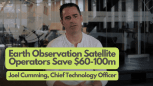
"At SkyWatch, we believe driving down the operational costs in Earth observation will improve profitability for satellite operators and improve fulfillment for data consumers," says Joel Cumming, Chief Technology Officer at SkyWatch. "Cost continues to be the greatest barrier for widespread capture and distribution of Earth observation data, and our mission is to find ways to make this data more accessible and affordable to those who need it."

TerraStream Edge will be made available to satellite operators via SkyWatch's TerraStream platform in 2023. To learn more about TerraStream, visit skywatch.com/terrastream.

Cost-effective access to Earth Observation data enables farmers to reliably predict crop yields to mitigate food insecurity worldwide.

KITCHENER, Ontario, November 21, 2022 (Newswire.com) - SkyWatch Space Applications Inc. (SkyWatch) announced today its collaboration with Farmdar, an agri-tech company based in Pakistan. Farmdar's app allows farmers to monitor their land, increase productivity, reduce farming costs, and reduce waste through artificial intelligence (AI) and remote sensing technologies.

Food production is a complex science. With the use of technology and analysis to predict the best growing conditions, agriculture has come a long way. However, the food production process isn't consistent or sustainable globally. Predicting crop yields is increasingly difficult due to climate change, often resulting in poor productivity and high waste. While access to insights and predictive analytics can mitigate these risks, these technologies have not historically been readily available, leading to increased food insecurity worldwide.

According to the Food and Agriculture Organization of the United Nations (FAO), 2019 Global Rankings, Pakistan's crop yield was only 60%, and 20% of the fruits and vegetables were wasted in the harvest. Analyzing rural Pakistan production was enough motivation for the Farmdar's founders, Muhammed Bukhari, Ibrahim Bukhari, and Muzaffar Manghi, to take action.

Using SAR and medium-resolution data, Farmdar's reports provide insights on crop classification, harvest monitoring, yield estimation, sowing classification, variety detection, NPK (Nitrogen, Phosphorous, Potassium) variable application reporting, water stress reporting, plant health, and stress reporting. 

In its early stages, Farmdar found that using only high-resolution optical data was expensive. Farmdar needed to balance quality data outputs and affordability. Using a mix of high- and medium-resolution data on their platform, SkyWatch made accessing 3-5m data easy and cost-effective, supporting their needs as one of the market's most affordable precision farming technologies. 

Pricing was not the only factor that mattered to Farmdar in a partnership. Farmdar chose SkyWatch as a partner because of SkyWatch's deep understanding of Farmdar's work and strong customer success practices. As a result, Farmdar's investment in earth observation data has seen a return for themselves and their customers.

"Any solution is only as good as the partner delivering it. There is a huge service aspect to technology, especially technology that is new to us, and the reassurance and confidence we get from a partner really is key," says Muzzafar Manghi, Co-Founder & Chief Operating Officer at Farmdar. "I can't emphasize enough how we've received that in spades from SkyWatch [and it] really encouraged us to do more with what SkyWatch offers."

"We are thrilled to be supporting the Farmdar team as the data provider for their precision agriculture projects across both Pakistan and the world," says Jordan Fox, SkyWatch's Senior Director of Sales and Customer Success. "This partnership was ultimately born out of a shared vision regarding what we can accomplish together for producers and the communities that rely on them. Together, we are fighting for food security by making precision agriculture more accessible, efficient, and intuitive."

EarthCache-X (EC-X) provides a new means for remote sensing partners to go to market.

KITCHENER, Ontario, October 11, 2022 (Newswire.com) - SkyWatch Space Applications Inc. ("SkyWatch"), a Canadian space tech company democratizing remote sensing data, announced today the launch of EarthCache-X (EC-X) and its partnerships with Capella Space, ICEYE, Satellogic (NYSE: SATL), and Vexcel Imaging, to deliver emerging data types to the commercial Earth observation (EO) market.

EarthCache-X (EC-X) provides a new means for remote sensing partners to go to market with flexible ways to handle data in custom formats that customers might require. With the addition of these industry-leading partners to SkyWatch's repertoire, customers will now have access to SAR, DEMs, aerial imagery and stereo/tri-stereo imagery.

EC-X presents a flexible platform for ingesting and distributing new data types to the EarthCache customer base. The way a customer searches for and receives data remains the same; EC-X still eliminates the friction of multiple contracts by providing a single business relationship with SkyWatch. With these new data providers, SkyWatch is able to create bespoke solutions for customers, defining the right product offerings and price points on a custom basis.

SkyWatch launches the EC-X program with an exceptional set of partners, each providing unique sensing technology that is underutilized by the commercial market today. Customers can now ensure that they are able to rapidly adopt and innovate around new sensing technologies, while our data partners grow their presence in the commercial market and learn how to optimize their solutions for those end markets. Over time, SkyWatch will migrate these in-demand sensing technologies into fully-integrated product offerings, with standardized pricing and output types.

Each of the inaugural EC-X partners was selected to bring strategic value to SkyWatch customers, in response to the demand SkyWatch is seeing in the market and on its Earth observation distribution platform, EarthCache.

Capella Space has the most responsive and agile SAR imaging services in the industry on the leading edge of rapid data acquisition for emergencies or tip and cue, with the added benefit of fully-automated scheduling, downlink, and processing architecture. Owning the world's largest SAR satellite constellation, ICEYE delivers proven and reliable Earth Observation solutions. ICEYE's high revisit and daily coherent change detection capabilities enable users to gain robust and comprehensive situational awareness. Satellogic is a vertically integrated EO satellite and data company that makes EO data more accessible, more reliable, and more affordable, offering the best price across the industry with the largest daily data collection capacity. Satellogic aims to deliver daily global remaps with the end goal of 200+ satellites in orbit. Vexcel runs the world's largest aerial imagery and geospatial data program, collecting multiple types of aerial content in 25+ countries. Vexcel delivers products such as Oblique, True Ortho, and Digital Surface Model data at up to 7.5cm resolution. Imagery and data are also optimized for ML/AI capabilities. 

The addition of SAR, DEMs, and aerial data enriches the SkyWatch aggregation model, which provides Earth observation data customers access to the largest network of industry-leading data sets within a single solution with a flexible, pay-per-use pricing model.

To learn more about EarthCache, visit getstarted.skywatch.com/ec-x

About SkyWatch

SkyWatch is on a mission to make Earth Observation data accessible to the world. Hundreds of trillions of pixels of our planet are captured from space every day. Drawing on the team's past experience in space data aggregation software, we are building the infrastructure to connect satellite data operators and application developers. The company raised a $17.2 million USD Series B in 2021 and is expected to double in size in the next 18 months.

SkyWatch's TerraStream platform will provide data management, ordering, processing, and delivery services for its new partners.

PARIS, France, September 15, 2022 (Newswire.com) - SkyWatch Space Applications Inc. ("SkyWatch"), a Canadian space technology startup, announced today at World Satellite Business Week two new partnerships in the TerraStream ecosystem: Esper Satellite Imagery and Nara Space.

The announcement of the two new TerraStream partners follows the announcement earlier this month of SkyWatch's partnership with Xplore Inc.

Esper, founded in 2019, is a Melbourne-based startup building space-based hyperspectral sensors for Earth observation to track climate metrics such as carbon emissions and carbon sinks for Oil and Gas, Agriculture, Mining and many other industries utilizing their proprietary sensor technology. Esper, with a mission to track 5B tons of carbon emissions annually, will launch their first pair of sensors in May of 2023, dubbed the "Over The Rainbow" mission, which will then be followed by a larger sensor network of 18 sensors in orbit.

Nara Space, founded in South Korea in 2015, is developing a nanosatellite called Observer-1, which is scheduled to launch in the second half of next year. Observer-1 is a commercial, microwave-sized optical satellite, and its main task is to observe the Earth. Although the native resolution is 1.5m, Nara Space is aiming to achieve a resolution of 0.5m through post-processing using their super-resolution algorithm.

SkyWatch's TerraStream platform will provide data management, ordering, processing, and delivery services for our new partners. Our end-to-end data management and distribution platform allows satellite operators to focus on developing core intellectual property while scaling a business with analysis-ready data and reduced time to market. Integration with SkyWatch's EarthCache platform, which provides application developers and GIS specialists with satellite imagery at scale, allows TerraStream customers to expand their market reach and add a new revenue stream to their business from day one.

"We're honored to have been selected by our friends at Esper Satellite Imagery and Nara Space to support their upcoming missions," says James Slifierz, CEO at SkyWatch. "Enabling new and exciting commercial satellite operators is the key to further democratizing Earth observation data, and we're thrilled to continue to work to bring high-quality and affordable datasets down to Earth." To learn more about TerraStream, visit https://skywatch.com/terrastream/.

ABOUT SKYWATCH

SkyWatch is on a mission to make Earth Observation and remote sensing data accessible to the world. Hundreds of trillions of pixels of our planet are captured from space every day. Drawing on the team's past experience in space data aggregation software, we are building the infrastructure to connect satellite data operators and application developers. The company raised a $17.2 million USD Series B in 2021 and is expected to double in size in the next 18 months. Learn more at https://skywatch.com.

SKYWATCH MEDIA CONTACT

Kelly Winter
Senior Director, Marketing
media@skywatch.com

TerraStream Enables Xplore to Get Data to Market Faster

KITCHENER, Ontario and REDMOND, Washington, September 12, 2022 (Newswire.com) - SkyWatch Space Applications Inc. ("SkyWatch"), a Kitchener-based space technology startup, and Xplore Inc., a commercial space company providing Space as a Service®, today announced they have signed a partnership agreement. The partnership will accelerate Xplore's commercial data distribution strategy and expand the diversity of accessible sensor data for the remote sensing market and new applications.

By leveraging TerraStream, Xplore eliminates the expense of building and managing complex and costly IT infrastructure, thereby reducing associated risks to platform design and data distribution. Xplore Founder and Chief Operating Officer Lisa Rich said, "With TerraStream, Xplore can focus on its mission to collect exquisite data products from space for our analytics customers."

Xplore Founder and COO, Lisa Rich
 Xplore Founder and COO, Lisa Rich
Credit: Xplore Inc.

TerraStream offers satellite data providers like Xplore an end-to-end solution to distribute their data products. Data providers on TerraStream can monitor current demand for Earth Observation data or other remote sensing data, track open and fulfilled orders, and monitor performance with real-time dashboards.

"Our team delivers a data distribution solution for remote sensing applications that is second to none," said Cristian Sternat, Director of Business Development at SkyWatch. "We are honored that Xplore has chosen SkyWatch to handle this critical element of their business."

Xplore's partnership with TerraStream opens up new markets and provides an accelerated path to revenue growth by connecting to EarthCache, SkyWatch's remote sensing platform. Selling data on EarthCache offers a practical and economical way to grow revenue from our global remote sensing data marketplace.

The addition of Xplore's various datasets, which include optical, hyperspectral and video sensor data, enriches the diversity of sensor data for the remote sensing market all within a single solution with a flexible, pay-per-use pricing model for remote sensing data customers.

To learn more about TerraStream, visit www.skywatch.com/terrastream/.

About SkyWatch
SkyWatch is on a mission to make Earth Observation and remote sensing data accessible to the world. Hundreds of trillions of pixels of our planet are captured from space every day. Drawing on the team's past experience in space data aggregation software, we are building the infrastructure to connect satellite data operators and application developers. The company raised a $17.2 million USD Series B in 2021 and is expected to double in size in the next 18 months.

About Xplore Inc.
Xplore provides Space as a Service®, offering data products, sensor tasking, mission operations software and payload hosting as a service to our customers. Xplore uses its highly-capable XCRAFT® platform to provide these services to government and commercial customers. The company operates out of its 22,000-square-foot, state-of-the-art facility in Redmond, Washington. Visit: https://www.xplore.com

SkyWatch Media Contact
Kelly Winter
Senior Director, Marketing
(519) 498-1997

Xplore Media Contact
Allie Hannigan
media@xplore.com
(425) 477-9455

The addition of VHR optical data to the EarthCache platform enriches the SkyWatch aggregation model, which provides Earth observation data customers access to the largest network of industry-leading data sets within a single solution with a flexible, pay-per-use pricing model.

KITCHENER, Ontario, July 26, 2022 (Newswire.com) - SkyWatch Space Applications Inc. ("SkyWatch"), a Kitchener-based space technology startup, announces today the immediate availability of Very High-Resolution (VHR) Earth observation data via its distribution platform, EarthCache.

VHR multispectral optical data, defined as 15-49cm native resolution, enables customers in various industries to make more accurate decisions, particularly in the areas of asset monitoring, coastal monitoring, risk mitigation, and detailed vegetation management. Through the EarthCache platform, SkyWatch offers the best small area unit economics for VHR data in the market.

Pleaides Neo Satellite Image Ⓒ Airbus DS 2022

The addition of VHR optical data to the EarthCache platform enriches the SkyWatch aggregation model, which provides Earth observation data customers access to the largest network of industry-leading data sets within a single solution with a flexible, pay-per-use pricing model.

EarthCache is the simplest way to integrate commercial satellite imagery into any application, removing the complexity out of Earth observation data sourcing and processing. EarthCache is a single access point to the best Earth observation data available across all industries, with data from leading providers including Airbus, Planet, SIIS, 21AT, and ESA.

EarthCache customers also have access to a robust, easy-to-use API suite, standardized analysis-ready data, and custom parameters for data requests, allowing geospatial solutions providers to take their products to market faster.

To learn more about EarthCache, visit www.skywatch.com/earthcache.

About SkyWatch

SkyWatch is on a mission to make Earth Observation data accessible to the world. Hundreds of trillions of pixels of our planet are captured from space every day. Drawing on the team's past experience in space data aggregation software, we are building the infrastructure to connect satellite data operators and application developers. The company raised a $17.2 million USD Series B in 2021 and is expected to double in size in the next 18 months.

Media Contact

Kelly Winter
Senior Director, Marketing
+1 519 498 1997
kelly@skywatch.com

SAN DIEGO, July 11, 2022 - SkyWatch Space Applications Inc. ("SkyWatch"), a Kitchener-based space technology company, announces today its Esri Partner Network relationship to deliver satellite imagery for mapping projects and spatial analytics via Esri's ArcGIS software.

The integration of SkyWatch's Earth observation (EO) platform, EarthCache, with ArcGIS provides a single aggregate source of EO data from multiple providers. SkyWatch's transparent pay-as-you-go pricing model provides ArcGIS users with the ability to access high-quality satellite imagery within ArcGIS, without the requirement to maintain commercial relationships with each data provider. Additionally, users are able to discover and acquire data for small areas of interest, which has traditionally been challenging due to minimum area requirements and other limiting factors.

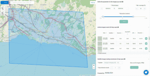
Screenshot of the Esri ArcGIS platform with satellite imagery, sourced from SkyWatch, overlaid on the map.

EarthCache is the simplest way to integrate commercial satellite imagery into any application, removing the complexity out of Earth observation data sourcing and processing. EarthCache is a single access point to the best Earth observation data available for application developers and geospatial experts across all industries.

"Esri is the global leader in geographic information systems (GIS) technology and location intelligence and we're thrilled to partner with Esri to deliver Earth observation data to ArcGIS customers," says David Proulx, Chief Product Officer at SkyWatch. "We're looking forward to unlocking simple access to EO data for the geospatial community through the integration of EarthCache and ArcGIS."

To learn more about SkyWatch and the closed Beta of our integration with ArcGIS, visit Booth 826 at the 2022 ESRI User Conference or visit www.skywatch.com/esri.

About SkyWatch
SkyWatch is on a mission to democratize remote-sensing data through a simple user experience. Drawing on the team's past experience in space data aggregation software, SkyWatch is building the infrastructure to connect satellite data providers and geospatial data consumers.

Media Contact:
Kelly Winter, Senior Director of Marketing
SkyWatch
media@skywatch.com

SkyWatch Joins Esri Partner Network; Closed Beta ArcGIS Integration
linkedin facebook pinterest youtube rss twitter instagram facebook-blank rss-blank linkedin-blank pinterest youtube twitter instagram