What is the difference between aerial and satellite imagery?

Watch What is the difference between an aerial photo and a satellite image? Aerial photos and satellite imagery are two types of remote sensing data with different characteristics, advantages, and limitations. Aerial photos are captured at relatively low altitudes and offer higher spatial resolution than satellite imagery, which can provide global coverage and regular revisits […]
Advantages and Disadvantages of Remote Sensing

Remote sensing, a powerful technology that allows us to gather information about the Earth’s surface or other objects from a distance, has revolutionized various fields, from environmental monitoring to urban planning. While it offers numerous advantages, it is crucial to acknowledge there are disadvantages of remote sensing that can feel like drawbacks. In this article, we will delve into the advantages and disadvantages of remote sensing and explore the factors that can impact its effectiveness.
Explaining the Six Components of a Remote Sensing System

TL;DR: A remote sensing system captures data about the Earth without touching it. It works in six steps: a light source, the atmosphere, a target, a sensor, processing, and analysis. Below, we explain each part in plain terms, show where it’s used, and point you to where you can get the data. Remote sensing lets […]
Canada’s Contribution to Space: A Look at Canadian Satellites

Many countries contribute to space with satellites, but how many Canadian satellites exist? Canada has a long history of satellite technology and space research, including the development of the Canadarm, a remote-controlled robotic arm which deployed, captured and repaired satellites, positioned astronauts, maintained equipment, and moved cargo. The Canadian Space Agency (CSA) has played a […]
Five Ways Satellite Imagery Is Transforming The Mining Industry

Satellite imagery has changed how we see our planet. Images and data from space now guide decisions in farming, disaster response, and dozens of other fields. Mining is one of the industries gaining the most. Satellite imagery and other Earth observation (EO) data help teams explore for resources, plan surveys, map sites, and track environmental […]
Access SatelliteVu High-Resolution Thermal Imagery With SkyWatch
KITCHENER, Ontario, September 19, 2023 (Newswire.com) – SkyWatch, a leader in the remote sensing data technology industry, announced today its partnership with SatelliteVu (“SatVu”), a UK-based provider of high-resolution thermal (infrared) imagery. The addition of SatelliteVu’s thermal imagery to SkyWatch’s EarthCache platform enables customers to leverage high-resolution, precision imagery for climate, environmental, industrial, and intelligence […]
Industry Leaders Satellogic and SkyWatch Announce Partnership
PARIS, France, September 13, 2023 (Newswire.com) – Satellogic Inc. (NASDAQ: SATL), a leader in sub-meter resolution Earth Observation (“EO”) data collection, and SkyWatch, a leader in the remote sensing data technology industry, announced today, at World Satellite Business Week, their partnership to bring Satellogic’s highest resolution commercially available EO data to EarthCache customers. Satellogic’s EO […]
SkyWatch Announces Availability of Umbra SAR Data
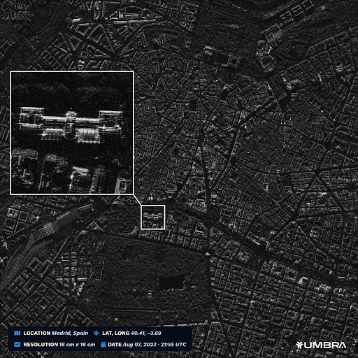
KITCHENER, Ontario, August 16, 2023 (Newswire.com) – SkyWatch, a leader in the remote sensing data technology industry, announced today its partnership with Umbra, a leader in advanced space radar technology. This partnership will allow customers to purchase Umbra’s industry-leading synthetic aperture radar (SAR) data via SkyWatch’s EarthCache platform. SkyWatch’s core mission is to make remote […]
SkyWatch Announces EarthCache Enterprise
KITCHENER, Ontario, July 26, 2023 (Newswire.com) – SkyWatch Space Applications Inc. (“SkyWatch”), a leader in the remote sensing technology industry, today announced the launch of EarthCache Enterprise, which enables organizations to more efficiently source and manage remote sensing data, with rich insights into data usage, expenditures, and performance. SkyWatch is well-known for launching the first API for […]
SkyWatch Announces EarthCache for ArcGIS Pro
KITCHENER, Ontario, May 30, 2023 (Newswire.com) – SkyWatch Space Applications Inc. (“SkyWatch”), a leader in the remote sensing data technology industry, announced today the availability of EarthCache for ArcGIS Pro. This integration makes SkyWatch’s EarthCache platform, which aggregates data from the world’s leading satellite data providers, available to Esri users within ArcGIS Pro, with one […]