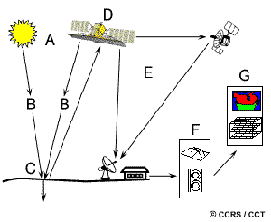
TL;DR: A remote sensing system captures data about the Earth without touching it. It works in six steps: an energy source, the atmosphere, a target, a sensor, processing, and analysis. Below, we explain each of the components of a remote sensing system in plain terms, show where they are used, and point you to where you can get the data.
Remote sensing lets us study the Earth from a distance. Sensors measure energy that the surface gives off or reflects, then turn it into usable data. Scientists, farmers, city planners, and analysts across many industries all rely on it.
Every system follows the same six-part framework. This guide walks through all six, with real examples and links to data sources.
The Six Components of a Remote Sensing System at a Glance
- Energy source – the energy that starts the process, usually the sun.
- Radiation and the atmosphere – the path that energy travels through.
- Target – the area you want to study.
- Sensor – the device that records the energy.
- Processing – turning raw signals into clean images.
- Analysis – making sense of the data.
Let’s look at each one.
1. Energy Source
Every system needs energy. Most of the time, that energy is sunlight. But sensors collect it in two different ways:
- Passive sensors measure energy that is already there, such as reflected sunlight. They need an outside energy source to work.
- Active sensors make their own energy. A synthetic aperture radar (SAR) satellite, for example, sends a signal to the ground and measures what bounces back. Because it supplies its own energy, it can image through clouds and at night.
Want to see the difference in action? Watch this short clip on active vs. passive sensors.
2. Radiation and the Atmosphere
Energy has to pass through the atmosphere to reach the target and the sensor. Along the way, water vapor and gases can change it.
These changes can throw off the data. To fix this, scientists correct for atmospheric effects so the final readings stay accurate. The atmosphere is a core part of the system, not just a hurdle.
3. Target
The target is the area you want to study, often the Earth’s surface. It could be:
- A forest
- A city
- A glacier
- Any other geographic feature
Each target has its own traits, such as how much energy it reflects, how much heat it gives off, and its temperature. These traits shape what data you collect and which sensor you use.
4. Sensor
The sensor captures the energy that the target gives off or reflects. Sensors sit on satellites, aircraft, or platforms on the ground.
Different sensors read different parts of the electromagnetic spectrum, such as visible light, infrared, or microwave radiation. The one you choose depends on what you want to measure.
SkyWatch specializes in satellite data. With SkyWatch EXPLORE, you can browse imagery from many sensor types and pick the output that fits your project.
5. Processing
Raw sensor data is not ready to use. It first needs cleaning up.
Processing corrects for things like:
- Atmospheric interference
- Sensor quirks
- Geometric distortion
The result is a clean image, or another usable format, that is ready for analysis.
6. Analysis
This is where the data becomes useful. Analysts interpret the processed images to answer real questions.
Analysis can be as simple as looking at a picture or as advanced as:
- Classifying land cover
- Detecting change over time
- Taking precise measurements
The insights feed countless real-world applications.
How the Components of a Remote Sensing System Are Used
Once the six components work together, remote sensing supports work across many fields.
Environmental monitoring. Track environmental changes like deforestation, land degradation, and natural disasters. It also helps measure pollution and protect biodiversity.
Agriculture. Farmers use remote sensing data to manage crops, check soil health, and improve yields. It is a key tool in precision agriculture.
Urban planning. City planners study land use, urban sprawl, and infrastructure. The data helps them manage growth and spot risk-prone areas.
Disaster management. During hurricanes, earthquakes, and wildfires, remote sensing guides emergency response, damage assessment, and preparedness.
Where to Get Remote Sensing Data
Getting data is easier than ever. Here are three main sources.
Government agencies
Agencies like NASA, the European Space Agency (ESA), and the U.S. Geological Survey (USGS) offer free remote sensing data. They keep large archives of satellite imagery.
Commercial providers and marketplaces
Companies such as Vantor (formerly Maxar), Airbus, and Planet Labs sell high-resolution imagery and analytics.
SkyWatch works as an aggregator. SkyWatch EXPLORE makes buying data from top providers simple and affordable, giving you the same imagery as the commercial providers but with more flexibility and choice. Teams that need enterprise-scale data management and procurement can also use SkyWatch HUB.
Two examples of how businesses use this data:
- Real estate. One customer measured shorelines in a coastal region to estimate investment value. By tracking whether the shoreline was eroding over time, investors could make a smarter decision.
- AgriTech. Farmdar uses remote sensing to fight food waste and food insecurity in Pakistan.
Online platforms
Tools like Google Earth Engine and the Copernicus Data Space Ecosystem give you data plus an easy-to-use interface for analysis.
The Bottom Line
Remote sensing changed how we observe the Earth. The six components of a remote sensing system, from the energy source to the final analysis, work together as one system to collect and explain valuable data.
That data drives progress in environmental monitoring, agriculture, urban planning, and disaster response. And with government agencies, commercial providers, and online platforms all offering access, it has never been easier to put remote sensing to work.
Ready to get started? Browse satellite imagery on SkyWatch EXPLORE.