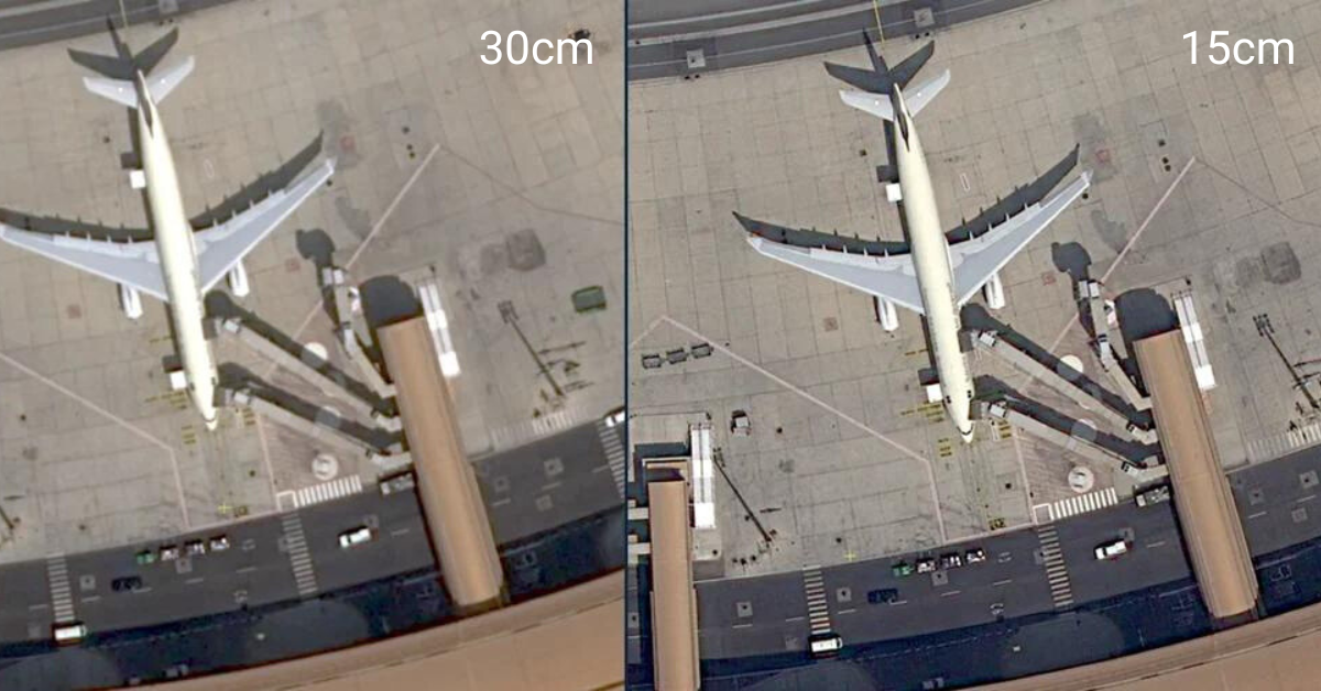
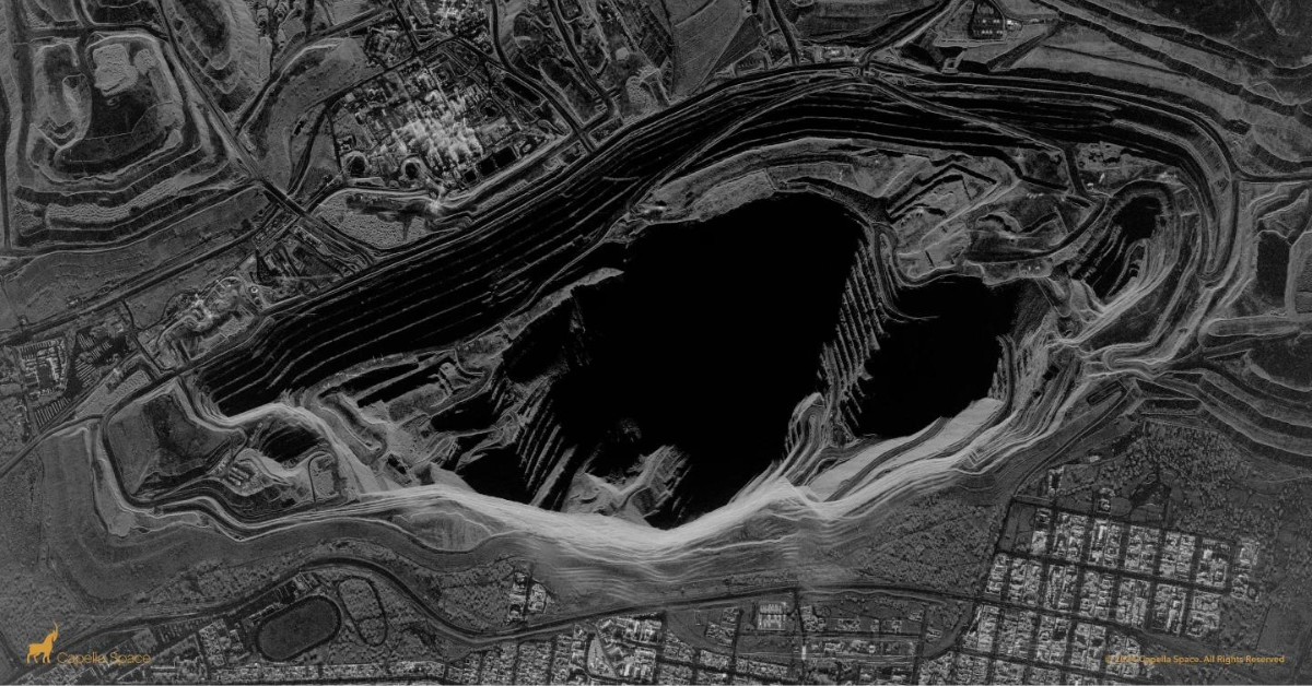
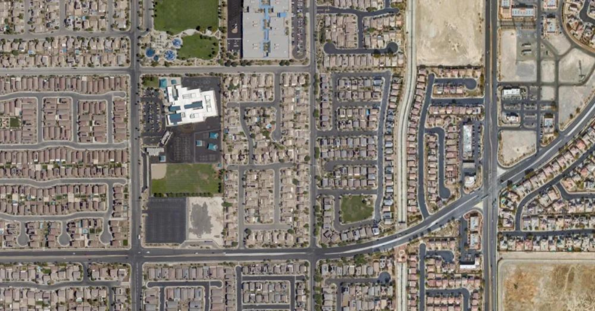
Skip to content
Data Products
Satellite Imagery
Commercial Satellite Imagery
Open Data
Aerial Imagery
Software
EXPLORE
HUB
MAP
BUILD
CONNECT
Solutions
Architecture, Engineering & Construction
Energy, Oil & Gas
Forestry
Media
Mining & Natural Resources
Utilities
Developers
Documentation
Resources
Blog
What Is Series
CONTACT US
Order Imagery
Data Products
Satellite Imagery
Commercial Satellite Imagery
Open Data
Aerial Imagery
Software
EXPLORE
HUB
MAP
BUILD
CONNECT
Solutions
Architecture, Engineering & Construction
Energy, Oil & Gas
Media
Mining & Natural Resources
Forestry
State & Local Government
Utilities
Start Exploring
Data Products
Satellite Imagery
Commercial Satellite Imagery
Open Data
Aerial Imagery
Software
EXPLORE
HUB
MAP
BUILD
CONNECT
Solutions
Architecture, Engineering & Construction
Energy, Oil & Gas
Media
Mining & Natural Resources
Forestry
State & Local Government
Utilities
Start Exploring
Blog
The SkyWatch Blog
Our official blog with insights into the Earth observation and remote sensing industries.
Satellite Imagery Pricing: What You Need to Know
November 7, 2025
Aerial Imagery is Now Available in Content Store for ArcGIS
October 23, 2025
Highest Resolution Satellite Imagery: What You Should Know
October 16, 2025
How To Buy Satellite Images
September 20, 2025
A New Perspective: Aerial Imagery Now Available on SkyWatch
July 17, 2025
What Is Satellite Imagery? A Guide for Modern Businesses
July 12, 2025
Enhancing Asset Monitoring in Oil and Gas with Satellite Technology
June 13, 2025
Drones vs Satellites: What’s Better for Project Site Monitoring?
June 13, 2025
Remote Sensing for Oil Pipeline Monitoring: What You Need to Know
June 13, 2025
Solar Farm Site Selection Made Easy with Satellite Intelligence
June 13, 2025
The New Standard in Solar Farm Monitoring: Faster, Safer, Smarter
June 13, 2025
Cut Costs and Boost Efficiency in Renewable Energy Site Planning
June 13, 2025
Revolutionizing Clean Energy: Wind Farm Mapping Tools That Deliver Results
June 13, 2025
New Era of Oil Field Site Monitoring: Secure, Scalable, Smart
June 13, 2025
The Need for Environmental Impact Assessments of Oil Fields
June 13, 2025
Oil and Gas Infrastructure Monitoring That Delivers Results
June 13, 2025
4 Ways Investors Use Satellite Imagery
January 31, 2025
Announcing SAR Tasking Availability on SkyWatch HUB and EXPLORE
January 16, 2025
Check out the Latest Version of our ArcGIS Pro Add-In
January 14, 2025
ImageSat International (ISI) Data Now Available via SkyWatch
November 20, 2024
The Consumerization of Geospatial Data
October 29, 2024
Introducing SkyWatch HUB
September 26, 2024
SkyWatch Signs Data Distribution Agreement with IMPRO
September 11, 2024
Wyvern Hyperspectral Data Now Available to SkyWatch Customers
September 4, 2024
Leveraging Satellite Imagery For Reforestation
July 18, 2024
Explore Very High Resolution Data with SkyWatch
July 2, 2024
INTRODUCING THE SKYWATCH PLATFORM
May 17, 2024
How Al Jazeera Leverages Satellite Imagery for Media Analysis
April 23, 2024
Enhancing News Coverage with Satellite Imagery Analysis
April 16, 2024
Changing the Oil and Gas Industry with Satellite Data
March 19, 2024
Capella Space Selects SkyWatch as Platform Partner
March 5, 2024
Urban Sky 2024 Urban Catalog & Custom Tasking Now Available
February 12, 2024
How Local Governments Use Satellite Data
January 30, 2024
Do More With Very High-Resolution Imagery With SkyWatch
January 25, 2024
Advantages and Disadvantages of Remote Sensing
January 9, 2024
Explaining the Six Components of a Remote Sensing System
December 18, 2023
Canada’s Contribution to Space: A Look at Canadian Satellites
December 5, 2023
Five Ways Satellite Imagery Is Transforming The Mining Industry
November 22, 2023
Task Satellites to Capture Amazing Photos From Space With SkyWatch
January 25, 2023
How To Use Satellite Imagery In A Utility Use Case
December 15, 2022
Making Earth Observation Data Easy To Distribute And Access
December 6, 2022
How Satellite Operators Save $60-100m To Monetize Their Data
December 6, 2022
How Do You Get Data From Satellites To Earth?
December 6, 2022
Earth Observation Data: Understanding Resolutions
November 23, 2022
SkyWatch Partners With Pakistan-Based Farmdar
November 18, 2022
TerraStream Includes All The Partners You Need
November 15, 2022
How Investors Use Satellite Imagery.
November 15, 2022
What Data Do You Need
November 14, 2022
Earth Observation: Saving Lives In Oil And Gas
November 14, 2022
Why GIS Specialists Are Shifting From Mapping to Monitoring
October 18, 2022
How to Choose the Right Satellite Imagery Provider
September 26, 2022
Case Study with BAP Intel: From Hobbyist to Professional Analyst
August 11, 2022
Using multiple sensors: What is a Tip and Cue Sensor?
August 5, 2022
Types of Earth Observation Data
August 5, 2022
The Story Of SkyWatch – High Resolution Satellite Imagery
August 5, 2022
The Ultimate Satellite Imagery Guide
July 19, 2022
The 5 Coolest Uses For Satellite Imagery
July 11, 2022
5 Ways to Use Satellite Data For Health
July 11, 2022
Mapping racial diversity with satellite data
July 11, 2022
Monitoring animal populations from space
July 11, 2022
Monitoring forest fires with satellites
July 11, 2022
What resolution do I need when using satellite data?
July 11, 2022
Modelling pollutant exposure from space
July 11, 2022
Estimating soil moisture from satellite data
July 11, 2022
Improving flood forecasting with Earth observation data
July 11, 2022
Using spatial and aerial imagery to estimate crop surfaces
July 11, 2022
How SkyWatch Handled The First Few Months Of The Pandemic
May 14, 2022
SkyWatch: A Platform for All of Earth Observation
May 14, 2022
Locating uranium deposits with satellite data
April 28, 2022
How Government Agencies Use SkyWatch
April 28, 2022
Counting Seals in Cape Cod With Satellites
April 28, 2022
Studying Volcanoes and Earthquakes with Synthetic Aperture Radar
April 28, 2022
Helping in the aftermath of Hurricane Dorian
April 28, 2022
How to Use Satellite Imagery to Reduce Risk in Oil & Gas
April 28, 2022
Top 10 Free Sources of Satellite Data
April 28, 2022
What does real-time satellite data really look like?
April 28, 2022
How an Intelligence company uses SkyWatch EarthCache
April 28, 2022
How a Precision Agriculture Application Uses SkyWatch EarthCache
April 28, 2022
Design and Implement Sustainability Strategies With Satellite Data
April 28, 2022
AI in Space
April 28, 2022
Understanding data transfers
April 28, 2022
Understanding how Satellite Images are created
April 28, 2022
Understanding Orbits
April 28, 2022
What’s the difference between multispectral, hyperspectral, and SAR?
April 28, 2022
How an infrastructure company uses satellite data
April 28, 2022
How an Artificial Intelligence company uses satellite data
April 28, 2022
5 Benefits of Using Satellite Imagery Over Drones
April 28, 2022
Satellite Image Outputs and Their Applications
April 28, 2022
Why Buying Satellite Imagery Used to Be So Hard
April 28, 2022
SkyWatch provides Orbital Eye with an efficient alternative to helicopter monitoring
April 28, 2022
Top Four Coolest Ways Satellite Imagery is Being Used
April 27, 2022
B.C. Students Representing Canada at Global CanSat Comp
September 29, 2021
We're on a mission to democratize remote sensing data through a simple user experience
About us
Careers
Press & Media
About us
Careers
Press & Media
Recent News
Spexi and SkyWatch Partner to Bring First-Ever Standardized Drone Imagery to Esri and SkyWatch Users
Eagleview and SkyWatch Announce Alliance to Expand Access to Ultra High-Resolution Aerial Imagery
Esri Launches Content Store for ArcGIS
See all news
By Role
For Business Users
For Business Leaders
For Geospatial Analysts
For Developers
For Data Providers
For Business Users
For Business Leaders
For Geospatial Analysts
For Developers
For Data Providers
By Vertical
Architecture, Engineering & Construction
Energy, Oil & Gas
Forestry
Media
Mining & Natural Resources
Utilities
Architecture, Engineering & Construction
Energy, Oil & Gas
Forestry
Media
Mining & Natural Resources
Utilities
Recent Use Cases
Enhancing Asset Monitoring in Oil and Gas with Satellite Technology
Drones vs Satellites: What’s Better for Project Site Monitoring?
Remote Sensing for Oil Pipeline Monitoring: What You Need to Know